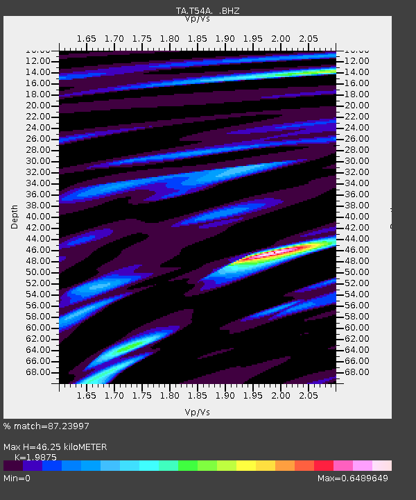
T54A Tazewell, VA, USA - Earthquake Result Viewer

Earthquake location: Queen Charlotte Islands Region
Earthquake latitude/longitude: 51.2/-130.4
Earthquake time(UTC): 2013/09/03 (246) 20:19:06 GMT
Earthquake Depth: 2.7 km
Earthquake Magnitude: 6.1 MWW, 6.0 MWB, 6.1 MWW, 6.1 MWC, 6.2 MI, 6.2 MWC
Earthquake Catalog/Contributor: NEIC PDE/NEIC COMCAT
Network: TA USArray Transportable Network (new EarthScope stations)
Station: T54A Tazewell, VA, USA
Lat/Lon: 37.06 N/81.58 W
Elevation: 852 m
Distance: 37.1 deg
Az: 93.085 deg
Baz: 308.314 deg
Ray Param: 0.076347776
Estimated Moho Depth: 46.25 km
Estimated Crust Vp/Vs: 1.99
Assumed Crust Vp: 6.159 km/s
Estimated Crust Vs: 3.099 km/s
Estimated Crust Poisson's Ratio: 0.33
Radial Match: 87.23997 %
Radial Bump: 394
Transverse Match: 59.714394 %
Transverse Bump: 400
SOD ConfigId: 626651
Insert Time: 2014-04-18 08:46:29.364 +0000
GWidth: 2.5
Max Bumps: 400
Tol: 0.001

Signal To Noise

ChannelStoNSTALTA
TA:T54A: :BHZ:20130903T20:25:46.949985Z8.1735535.990928E-77.329649E-8
TA:T54A: :BHN:20130903T20:25:46.949985Z3.70151382.2224552E-76.004179E-8
TA:T54A: :BHE:20130903T20:25:46.949985Z3.68210322.9808035E-78.0953825E-8
Arrivals
Ps7.9 SECOND
PpPs21 SECOND
PsPs/PpSs29 SECOND