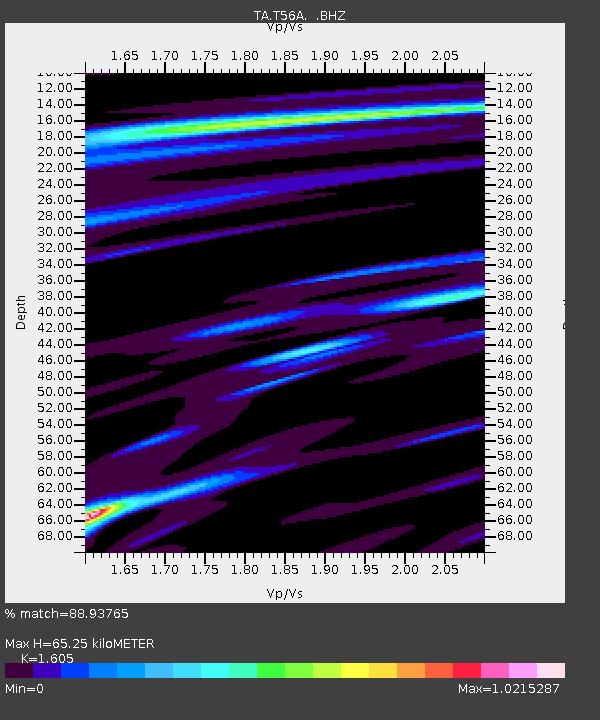
T56A Rocky Mt, VA, USA - Earthquake Result Viewer
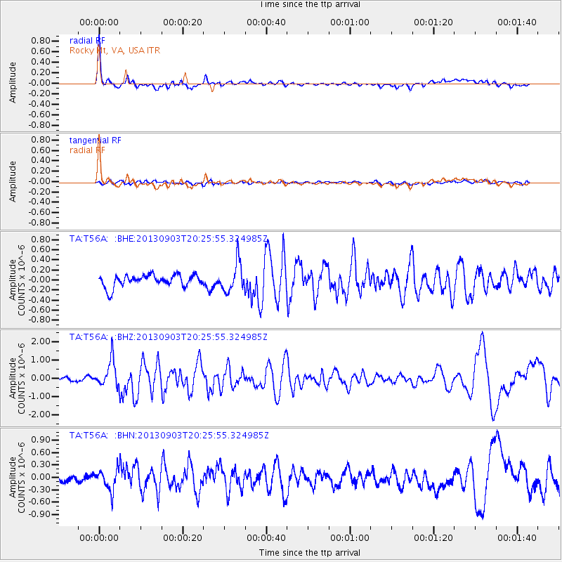
Earthquake location: Queen Charlotte Islands Region
Earthquake latitude/longitude: 51.2/-130.4
Earthquake time(UTC): 2013/09/03 (246) 20:19:06 GMT
Earthquake Depth: 2.7 km
Earthquake Magnitude: 6.1 MWW, 6.0 MWB, 6.1 MWW, 6.1 MWC, 6.2 MI, 6.2 MWC
Earthquake Catalog/Contributor: NEIC PDE/NEIC COMCAT
Network: TA USArray Transportable Network (new EarthScope stations)
Station: T56A Rocky Mt, VA, USA
Lat/Lon: 37.03 N/80.03 W
Elevation: 387 m
Distance: 38.1 deg
Az: 91.87 deg
Baz: 308.278 deg
Ray Param: 0.07579218
Estimated Moho Depth: 65.25 km
Estimated Crust Vp/Vs: 1.61
Assumed Crust Vp: 6.159 km/s
Estimated Crust Vs: 3.837 km/s
Estimated Crust Poisson's Ratio: 0.18
Radial Match: 88.93765 %
Radial Bump: 400
Transverse Match: 56.83237 %
Transverse Bump: 400
SOD ConfigId: 626651
Insert Time: 2014-04-18 08:46:34.280 +0000
GWidth: 2.5
Max Bumps: 400
Tol: 0.001

Signal To Noise

ChannelStoNSTALTA
TA:T56A: :BHZ:20130903T20:25:55.324985Z6.63426167.5674546E-71.1406627E-7
TA:T56A: :BHN:20130903T20:25:55.324985Z1.94001952.5495234E-71.314174E-7
TA:T56A: :BHE:20130903T20:25:55.324985Z2.47932742.9766542E-71.2005893E-7
Arrivals
Ps6.9 SECOND
PpPs26 SECOND
PsPs/PpSs33 SECOND