U51A La Follette, TN, USA - Earthquake Result Viewer
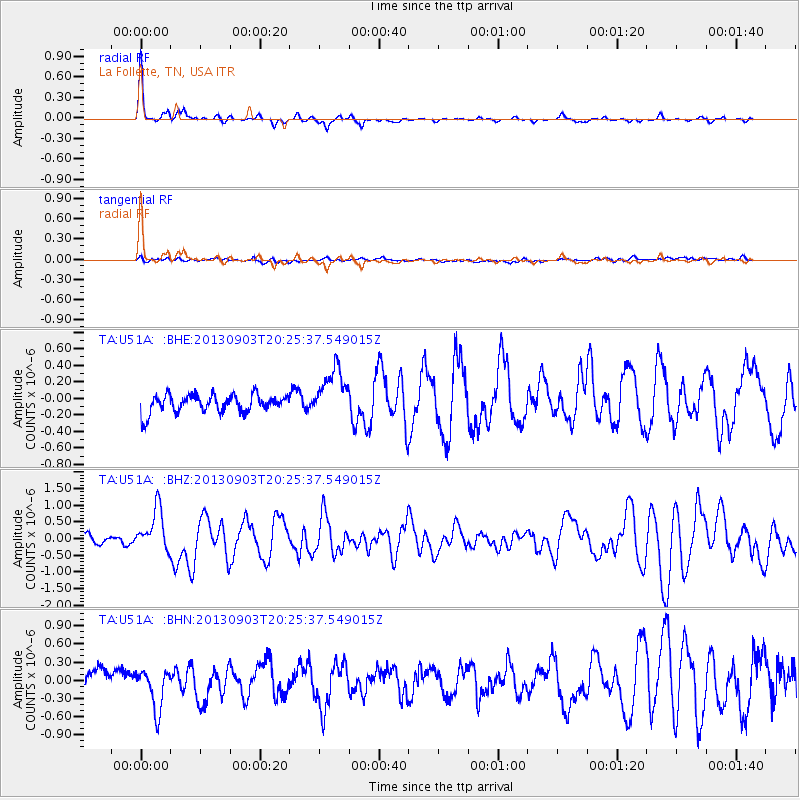
Earthquake location: Queen Charlotte Islands Region
Earthquake latitude/longitude: 51.2/-130.4
Earthquake time(UTC): 2013/09/03 (246) 20:19:06 GMT
Earthquake Depth: 2.7 km
Earthquake Magnitude: 6.1 MWW, 6.0 MWB, 6.1 MWW, 6.1 MWC, 6.2 MI, 6.2 MWC
Earthquake Catalog/Contributor: NEIC PDE/NEIC COMCAT
Network: TA USArray Transportable Network (new EarthScope stations)
Station: U51A La Follette, TN, USA
Lat/Lon: 36.38 N/84.02 W
Elevation: 472 m
Distance: 36.0 deg
Az: 96.04 deg
Baz: 309.236 deg
Ray Param: 0.07694858
Estimated Moho Depth: 59.25 km
Estimated Crust Vp/Vs: 2.10
Assumed Crust Vp: 6.476 km/s
Estimated Crust Vs: 3.091 km/s
Estimated Crust Poisson's Ratio: 0.35
Radial Match: 90.96088 %
Radial Bump: 234
Transverse Match: 44.595642 %
Transverse Bump: 400
SOD ConfigId: 626651
Insert Time: 2014-04-18 08:46:54.901 +0000
GWidth: 2.5
Max Bumps: 400
Tol: 0.001

Signal To Noise

ChannelStoNSTALTA
TA:U51A: :BHZ:20130903T20:25:37.549015Z5.6589136.245345E-71.1036297E-7
TA:U51A: :BHN:20130903T20:25:37.549015Z2.2771463.371177E-71.4804395E-7
TA:U51A: :BHE:20130903T20:25:37.549015Z2.76095272.9903816E-71.0830977E-7
Arrivals
Ps11 SECOND
PpPs27 SECOND
PsPs/PpSs37 SECOND