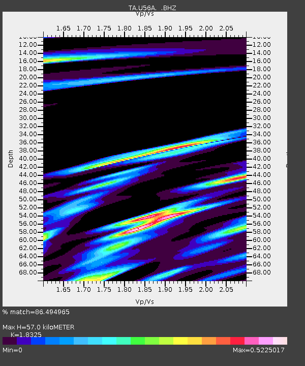
U56A King, NC, USA - Earthquake Result Viewer

Earthquake location: Queen Charlotte Islands Region
Earthquake latitude/longitude: 51.2/-130.4
Earthquake time(UTC): 2013/09/03 (246) 20:19:06 GMT
Earthquake Depth: 2.7 km
Earthquake Magnitude: 6.1 MWW, 6.0 MWB, 6.1 MWW, 6.1 MWC, 6.2 MI, 6.2 MWC
Earthquake Catalog/Contributor: NEIC PDE/NEIC COMCAT
Network: TA USArray Transportable Network (new EarthScope stations)
Station: U56A King, NC, USA
Lat/Lon: 36.35 N/80.38 W
Elevation: 363 m
Distance: 38.3 deg
Az: 93.015 deg
Baz: 308.969 deg
Ray Param: 0.07567442
Estimated Moho Depth: 57.0 km
Estimated Crust Vp/Vs: 1.83
Assumed Crust Vp: 6.159 km/s
Estimated Crust Vs: 3.361 km/s
Estimated Crust Poisson's Ratio: 0.29
Radial Match: 86.494965 %
Radial Bump: 400
Transverse Match: 57.756958 %
Transverse Bump: 400
SOD ConfigId: 626651
Insert Time: 2014-04-18 08:47:05.953 +0000
GWidth: 2.5
Max Bumps: 400
Tol: 0.001

Signal To Noise

ChannelStoNSTALTA
TA:U56A: :BHZ:20130903T20:25:57.024998Z4.77478466.343392E-71.3285191E-7
TA:U56A: :BHN:20130903T20:25:57.024998Z0.92329994.681943E-75.0708803E-7
TA:U56A: :BHE:20130903T20:25:57.024998Z1.20313123.177009E-72.6406173E-7
Arrivals
Ps8.2 SECOND
PpPs25 SECOND
PsPs/PpSs33 SECOND