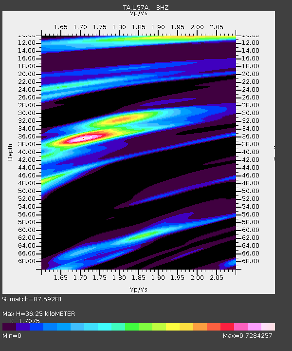
U57A Blanch, NC, USA - Earthquake Result Viewer

Earthquake location: Queen Charlotte Islands Region
Earthquake latitude/longitude: 51.2/-130.4
Earthquake time(UTC): 2013/09/03 (246) 20:19:06 GMT
Earthquake Depth: 2.7 km
Earthquake Magnitude: 6.1 MWW, 6.0 MWB, 6.1 MWW, 6.1 MWC, 6.2 MI, 6.2 MWC
Earthquake Catalog/Contributor: NEIC PDE/NEIC COMCAT
Network: TA USArray Transportable Network (new EarthScope stations)
Station: U57A Blanch, NC, USA
Lat/Lon: 36.43 N/79.34 W
Elevation: 178 m
Distance: 38.9 deg
Az: 92.06 deg
Baz: 308.84 deg
Ray Param: 0.07532541
Estimated Moho Depth: 36.25 km
Estimated Crust Vp/Vs: 1.71
Assumed Crust Vp: 6.419 km/s
Estimated Crust Vs: 3.759 km/s
Estimated Crust Poisson's Ratio: 0.24
Radial Match: 87.59281 %
Radial Bump: 238
Transverse Match: 59.195057 %
Transverse Bump: 400
SOD ConfigId: 626651
Insert Time: 2014-04-18 08:47:08.329 +0000
GWidth: 2.5
Max Bumps: 400
Tol: 0.001

Signal To Noise

ChannelStoNSTALTA
TA:U57A: :BHZ:20130903T20:26:02.10001Z3.08040365.801357E-71.8833106E-7
TA:U57A: :BHN:20130903T20:26:02.10001Z1.36011771.8832388E-71.3846146E-7
TA:U57A: :BHE:20130903T20:26:02.10001Z2.07167532.2254035E-71.0742048E-7
Arrivals
Ps4.3 SECOND
PpPs14 SECOND
PsPs/PpSs18 SECOND