V48A Smith Brothers Farm, Spring Hill, TN, USA - Earthquake Result Viewer
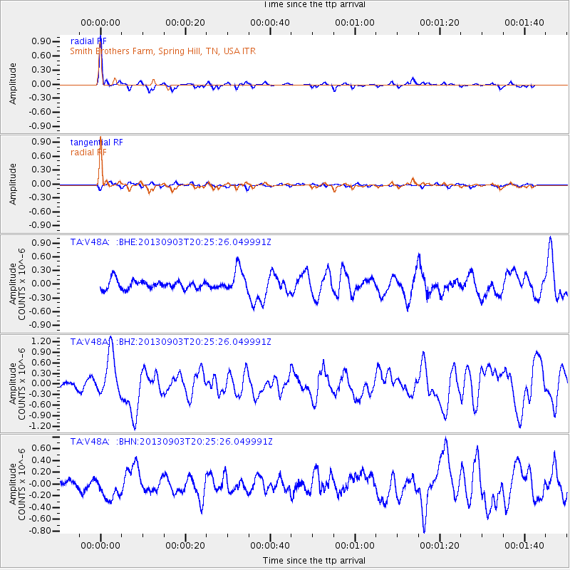
Earthquake location: Queen Charlotte Islands Region
Earthquake latitude/longitude: 51.2/-130.4
Earthquake time(UTC): 2013/09/03 (246) 20:19:06 GMT
Earthquake Depth: 2.7 km
Earthquake Magnitude: 6.1 MWW, 6.0 MWB, 6.1 MWW, 6.1 MWC, 6.2 MI, 6.2 MWC
Earthquake Catalog/Contributor: NEIC PDE/NEIC COMCAT
Network: TA USArray Transportable Network (new EarthScope stations)
Station: V48A Smith Brothers Farm, Spring Hill, TN, USA
Lat/Lon: 35.74 N/86.82 W
Elevation: 278 m
Distance: 34.6 deg
Az: 99.404 deg
Baz: 310.337 deg
Ray Param: 0.07765471
Estimated Moho Depth: 15.0 km
Estimated Crust Vp/Vs: 1.60
Assumed Crust Vp: 6.476 km/s
Estimated Crust Vs: 4.041 km/s
Estimated Crust Poisson's Ratio: 0.18
Radial Match: 80.29423 %
Radial Bump: 291
Transverse Match: 63.582882 %
Transverse Bump: 400
SOD ConfigId: 626651
Insert Time: 2014-04-18 08:47:18.454 +0000
GWidth: 2.5
Max Bumps: 400
Tol: 0.001

Signal To Noise

ChannelStoNSTALTA
TA:V48A: :BHZ:20130903T20:25:26.049991Z8.8261686.3153084E-77.15521E-8
TA:V48A: :BHN:20130903T20:25:26.049991Z2.02141.9731853E-79.761479E-8
TA:V48A: :BHE:20130903T20:25:26.049991Z2.80779052.6499913E-79.437995E-8
Arrivals
Ps1.5 SECOND
PpPs5.5 SECOND
PsPs/PpSs7.0 SECOND