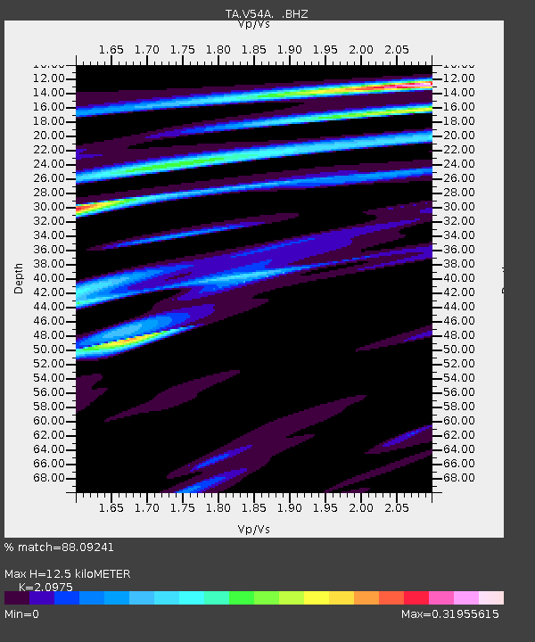
V54A Nebo, NC, USA - Earthquake Result Viewer

Earthquake location: Queen Charlotte Islands Region
Earthquake latitude/longitude: 51.2/-130.4
Earthquake time(UTC): 2013/09/03 (246) 20:19:06 GMT
Earthquake Depth: 2.7 km
Earthquake Magnitude: 6.1 MWW, 6.0 MWB, 6.1 MWW, 6.1 MWC, 6.2 MI, 6.2 MWC
Earthquake Catalog/Contributor: NEIC PDE/NEIC COMCAT
Network: TA USArray Transportable Network (new EarthScope stations)
Station: V54A Nebo, NC, USA
Lat/Lon: 35.78 N/81.95 W
Elevation: 448 m
Distance: 37.7 deg
Az: 95.037 deg
Baz: 309.646 deg
Ray Param: 0.07603468
Estimated Moho Depth: 12.5 km
Estimated Crust Vp/Vs: 2.10
Assumed Crust Vp: 6.419 km/s
Estimated Crust Vs: 3.06 km/s
Estimated Crust Poisson's Ratio: 0.35
Radial Match: 88.09241 %
Radial Bump: 400
Transverse Match: 51.608807 %
Transverse Bump: 400
SOD ConfigId: 626651
Insert Time: 2014-04-18 08:47:32.923 +0000
GWidth: 2.5
Max Bumps: 400
Tol: 0.001

Signal To Noise

ChannelStoNSTALTA
TA:V54A: :BHZ:20130903T20:25:51.799991Z4.77002766.739641E-71.4129145E-7
TA:V54A: :BHN:20130903T20:25:51.799991Z2.65411072.6210944E-79.875603E-8
TA:V54A: :BHE:20130903T20:25:51.799991Z4.22941833.732087E-78.8241144E-8
Arrivals
Ps2.3 SECOND
PpPs5.7 SECOND
PsPs/PpSs7.9 SECOND