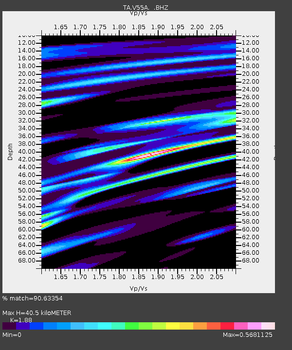
V55A Taylorsville, NC, USA - Earthquake Result Viewer

Earthquake location: Queen Charlotte Islands Region
Earthquake latitude/longitude: 51.2/-130.4
Earthquake time(UTC): 2013/09/03 (246) 20:19:06 GMT
Earthquake Depth: 2.7 km
Earthquake Magnitude: 6.1 MWW, 6.0 MWB, 6.1 MWW, 6.1 MWC, 6.2 MI, 6.2 MWC
Earthquake Catalog/Contributor: NEIC PDE/NEIC COMCAT
Network: TA USArray Transportable Network (new EarthScope stations)
Station: V55A Taylorsville, NC, USA
Lat/Lon: 35.85 N/81.21 W
Elevation: 306 m
Distance: 38.1 deg
Az: 94.325 deg
Baz: 309.51 deg
Ray Param: 0.07579535
Estimated Moho Depth: 40.5 km
Estimated Crust Vp/Vs: 1.88
Assumed Crust Vp: 6.419 km/s
Estimated Crust Vs: 3.414 km/s
Estimated Crust Poisson's Ratio: 0.30
Radial Match: 90.63354 %
Radial Bump: 353
Transverse Match: 51.797405 %
Transverse Bump: 400
SOD ConfigId: 626651
Insert Time: 2014-04-18 08:47:33.094 +0000
GWidth: 2.5
Max Bumps: 400
Tol: 0.001

Signal To Noise

ChannelStoNSTALTA
TA:V55A: :BHZ:20130903T20:25:55.274998Z6.8932645.630325E-78.167864E-8
TA:V55A: :BHN:20130903T20:25:55.274998Z3.47596382.9608069E-78.517945E-8
TA:V55A: :BHE:20130903T20:25:55.274998Z3.20077182.859759E-78.934591E-8
Arrivals
Ps5.9 SECOND
PpPs17 SECOND
PsPs/PpSs23 SECOND