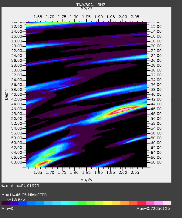
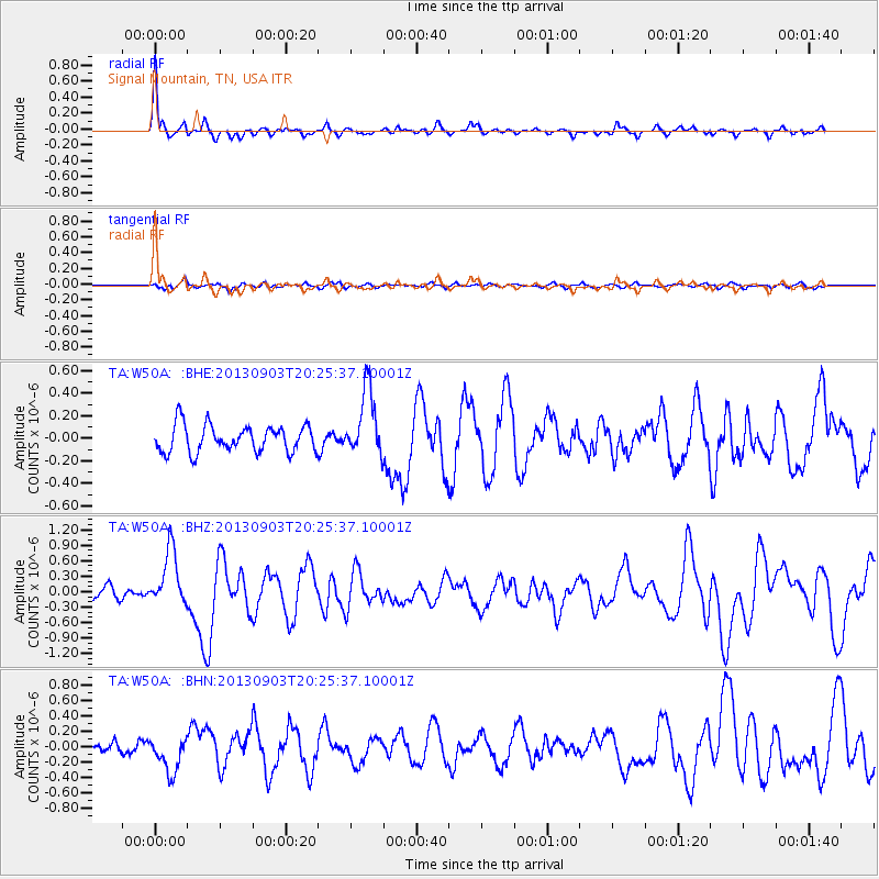
W50A Signal Mountain, TN, USA - Earthquake Result Viewer

Earthquake location: Queen Charlotte Islands Region
Earthquake latitude/longitude: 51.2/-130.4
Earthquake time(UTC): 2013/09/03 (246) 20:19:06 GMT
Earthquake Depth: 2.7 km
Earthquake Magnitude: 6.1 MWW, 6.0 MWB, 6.1 MWW, 6.1 MWC, 6.2 MI, 6.2 MWC
Earthquake Catalog/Contributor: NEIC PDE/NEIC COMCAT
Network: TA USArray Transportable Network (new EarthScope stations)
Station: W50A Signal Mountain, TN, USA
Lat/Lon: 35.20 N/85.31 W
Elevation: 587 m
Distance: 35.9 deg
Az: 98.727 deg
Baz: 310.657 deg
Ray Param: 0.076977186
Estimated Moho Depth: 46.25 km
Estimated Crust Vp/Vs: 2.00
Assumed Crust Vp: 6.35 km/s
Estimated Crust Vs: 3.179 km/s
Estimated Crust Poisson's Ratio: 0.33
Radial Match: 84.01973 %
Radial Bump: 391
Transverse Match: 52.820282 %
Transverse Bump: 400
SOD ConfigId: 626651
Insert Time: 2014-04-18 08:47:55.774 +0000
GWidth: 2.5
Max Bumps: 400
Tol: 0.001

Signal To Noise

ChannelStoNSTALTA
TA:W50A: :BHZ:20130903T20:25:37.10001Z3.85269285.511499E-71.4305576E-7
TA:W50A: :BHN:20130903T20:25:37.10001Z2.49595832.3349777E-79.355035E-8
TA:W50A: :BHE:20130903T20:25:37.10001Z2.49235562.9810107E-71.1960616E-7
Arrivals
Ps7.8 SECOND
PpPs20 SECOND
PsPs/PpSs28 SECOND