You are here: Home > Network List > TA - USArray Transportable Network (new EarthScope stations) Stations List
> Station Z41A Richland Creek Farm, El Dorado, AR, USA > Earthquake Result Viewer
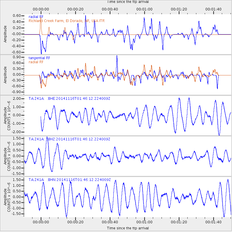
Z41A Richland Creek Farm, El Dorado, AR, USA - Earthquake Result Viewer
*The percent match for this event was below the threshold and hence no stack was calculated.
| Earthquake location: |
Iceland |
| Earthquake latitude/longitude: |
64.7/-17.6 |
| Earthquake time(UTC): |
2014/11/16 (320) 01:37:17 GMT |
| Earthquake Depth: |
10 km |
| Earthquake Magnitude: |
5.3 MW, 5.0 mb, 5.0 MS |
| Earthquake Catalog/Contributor: |
ISC/ISC |
|
| Network: |
TA USArray Transportable Network (new EarthScope stations) |
| Station: |
Z41A Richland Creek Farm, El Dorado, AR, USA |
| Lat/Lon: |
33.26 N/92.80 W |
| Elevation: |
62 m |
|
| Distance: |
54.2 deg |
| Az: |
272.958 deg |
| Baz: |
30.842 deg |
| Ray Param: |
$rayparam |
*The percent match for this event was below the threshold and hence was not used in the summary stack. |
|
| Radial Match: |
53.22133 % |
| Radial Bump: |
400 |
| Transverse Match: |
64.62439 % |
| Transverse Bump: |
400 |
| SOD ConfigId: |
3390531 |
| Insert Time: |
2019-04-15 00:51:35.624 +0000 |
| GWidth: |
2.5 |
| Max Bumps: |
400 |
| Tol: |
0.001 |
|
Signal To Noise
| Channel | StoN | STA | LTA |
| TA:Z41A: :BHZ:20141116T01:46:12.224009Z | 1.9225659 | 8.395462E-7 | 4.3668007E-7 |
| TA:Z41A: :BHN:20141116T01:46:12.224009Z | 0.9406067 | 8.252027E-7 | 8.773089E-7 |
| TA:Z41A: :BHE:20141116T01:46:12.224009Z | 0.7250565 | 4.926658E-7 | 6.7948605E-7 |
| Arrivals |
| Ps | |
| PpPs | |
| PsPs/PpSs | |


