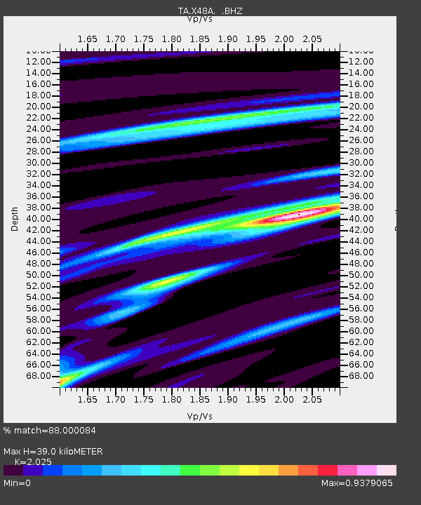
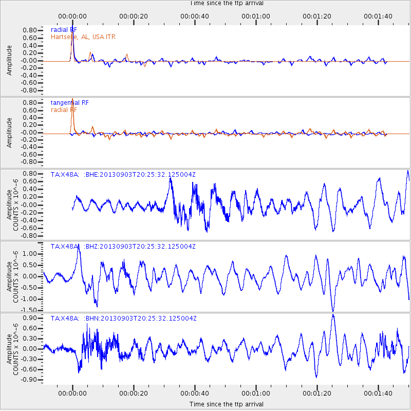
X48A Hartselle, AL, USA - Earthquake Result Viewer

Earthquake location: Queen Charlotte Islands Region
Earthquake latitude/longitude: 51.2/-130.4
Earthquake time(UTC): 2013/09/03 (246) 20:19:06 GMT
Earthquake Depth: 2.7 km
Earthquake Magnitude: 6.1 MWW, 6.0 MWB, 6.1 MWW, 6.1 MWC, 6.2 MI, 6.2 MWC
Earthquake Catalog/Contributor: NEIC PDE/NEIC COMCAT
Network: TA USArray Transportable Network (new EarthScope stations)
Station: X48A Hartselle, AL, USA
Lat/Lon: 34.45 N/87.05 W
Elevation: 180 m
Distance: 35.3 deg
Az: 101.304 deg
Baz: 311.766 deg
Ray Param: 0.077289514
Estimated Moho Depth: 39.0 km
Estimated Crust Vp/Vs: 2.03
Assumed Crust Vp: 6.476 km/s
Estimated Crust Vs: 3.198 km/s
Estimated Crust Poisson's Ratio: 0.34
Radial Match: 88.000084 %
Radial Bump: 261
Transverse Match: 61.458206 %
Transverse Bump: 400
SOD ConfigId: 626651
Insert Time: 2014-04-18 08:48:23.431 +0000
GWidth: 2.5
Max Bumps: 400
Tol: 0.001

Signal To Noise

ChannelStoNSTALTA
TA:X48A: :BHZ:20130903T20:25:32.125004Z6.8962746.391814E-79.2685035E-8
TA:X48A: :BHN:20130903T20:25:32.125004Z3.29857642.9807399E-79.036443E-8
TA:X48A: :BHE:20130903T20:25:32.125004Z3.47118543.2841214E-79.461095E-8
Arrivals
Ps6.6 SECOND
PpPs17 SECOND
PsPs/PpSs24 SECOND