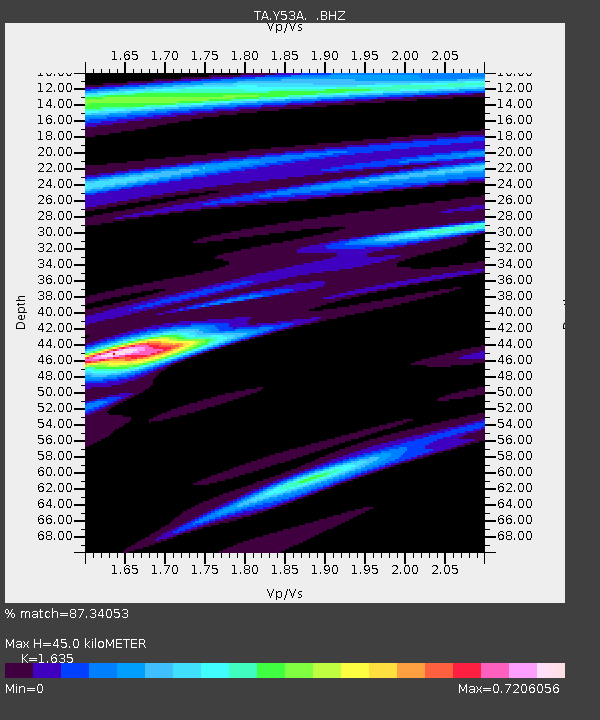
Y53A Monroe, GA, USA - Earthquake Result Viewer
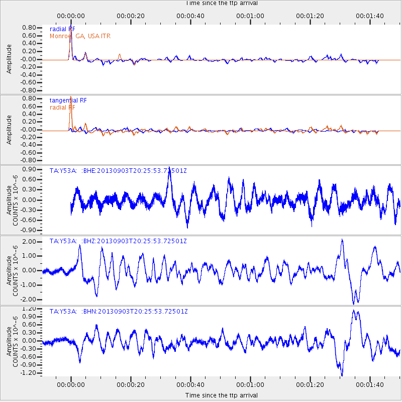
Earthquake location: Queen Charlotte Islands Region
Earthquake latitude/longitude: 51.2/-130.4
Earthquake time(UTC): 2013/09/03 (246) 20:19:06 GMT
Earthquake Depth: 2.7 km
Earthquake Magnitude: 6.1 MWW, 6.0 MWB, 6.1 MWW, 6.1 MWC, 6.2 MI, 6.2 MWC
Earthquake Catalog/Contributor: NEIC PDE/NEIC COMCAT
Network: TA USArray Transportable Network (new EarthScope stations)
Station: Y53A Monroe, GA, USA
Lat/Lon: 33.86 N/83.58 W
Elevation: 234 m
Distance: 37.9 deg
Az: 98.843 deg
Baz: 311.725 deg
Ray Param: 0.075901434
Estimated Moho Depth: 45.0 km
Estimated Crust Vp/Vs: 1.63
Assumed Crust Vp: 6.565 km/s
Estimated Crust Vs: 4.015 km/s
Estimated Crust Poisson's Ratio: 0.20
Radial Match: 87.34053 %
Radial Bump: 348
Transverse Match: 70.56865 %
Transverse Bump: 400
SOD ConfigId: 626651
Insert Time: 2014-04-18 08:48:53.978 +0000
GWidth: 2.5
Max Bumps: 400
Tol: 0.001

Signal To Noise

ChannelStoNSTALTA
TA:Y53A: :BHZ:20130903T20:25:53.72501Z7.61548767.295162E-79.5793766E-8
TA:Y53A: :BHN:20130903T20:25:53.72501Z3.62601972.9556176E-78.1511345E-8
TA:Y53A: :BHE:20130903T20:25:53.72501Z2.51089433.7749817E-71.503441E-7
Arrivals
Ps4.7 SECOND
PpPs17 SECOND
PsPs/PpSs21 SECOND