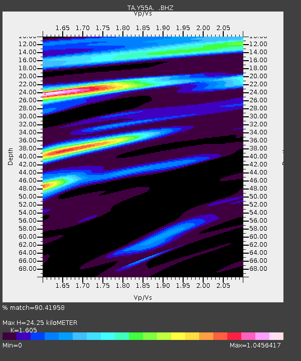
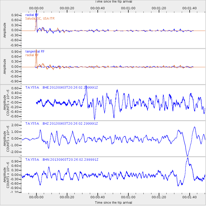
Y55A Saluda, SC, USA - Earthquake Result Viewer

Earthquake location: Queen Charlotte Islands Region
Earthquake latitude/longitude: 51.2/-130.4
Earthquake time(UTC): 2013/09/03 (246) 20:19:06 GMT
Earthquake Depth: 2.7 km
Earthquake Magnitude: 6.1 MWW, 6.0 MWB, 6.1 MWW, 6.1 MWC, 6.2 MI, 6.2 MWC
Earthquake Catalog/Contributor: NEIC PDE/NEIC COMCAT
Network: TA USArray Transportable Network (new EarthScope stations)
Station: Y55A Saluda, SC, USA
Lat/Lon: 33.94 N/81.86 W
Elevation: 164 m
Distance: 38.9 deg
Az: 97.211 deg
Baz: 311.404 deg
Ray Param: 0.07531158
Estimated Moho Depth: 24.25 km
Estimated Crust Vp/Vs: 1.61
Assumed Crust Vp: 6.565 km/s
Estimated Crust Vs: 4.09 km/s
Estimated Crust Poisson's Ratio: 0.18
Radial Match: 90.41958 %
Radial Bump: 400
Transverse Match: 59.859653 %
Transverse Bump: 400
SOD ConfigId: 626651
Insert Time: 2014-04-18 08:48:58.673 +0000
GWidth: 2.5
Max Bumps: 400
Tol: 0.001

Signal To Noise

ChannelStoNSTALTA
TA:Y55A: :BHZ:20130903T20:26:02.299991Z6.2942945.573813E-78.8553435E-8
TA:Y55A: :BHN:20130903T20:26:02.299991Z5.4840773.077768E-75.6121895E-8
TA:Y55A: :BHE:20130903T20:26:02.299991Z4.3703793.092893E-77.076945E-8
Arrivals
Ps2.4 SECOND
PpPs8.9 SECOND
PsPs/PpSs11 SECOND