Y56A Pelion, SC, USA - Earthquake Result Viewer
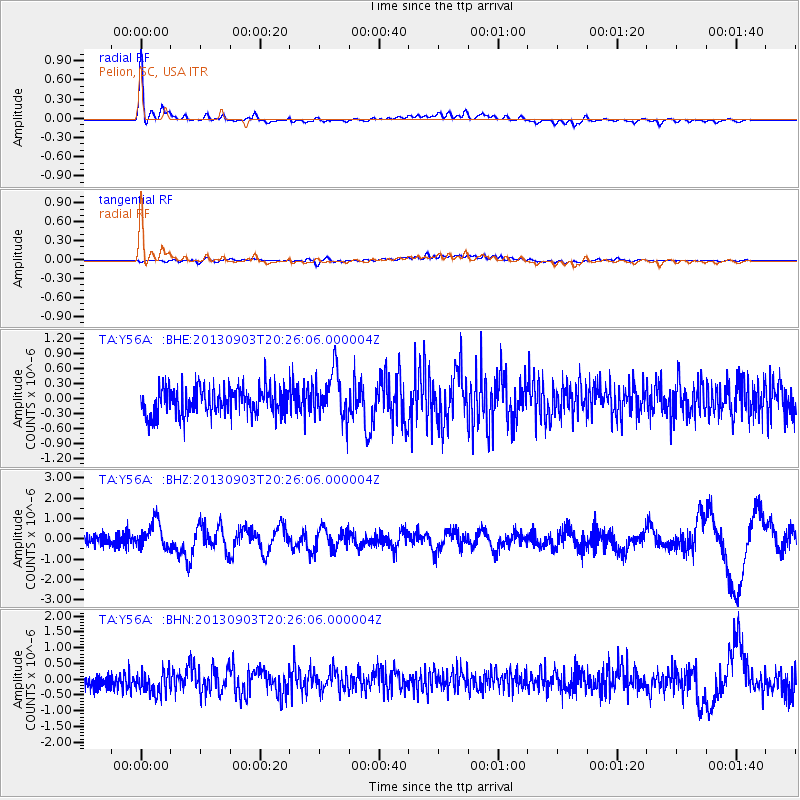
Earthquake location: Queen Charlotte Islands Region
Earthquake latitude/longitude: 51.2/-130.4
Earthquake time(UTC): 2013/09/03 (246) 20:19:06 GMT
Earthquake Depth: 2.7 km
Earthquake Magnitude: 6.1 MWW, 6.0 MWB, 6.1 MWW, 6.1 MWC, 6.2 MI, 6.2 MWC
Earthquake Catalog/Contributor: NEIC PDE/NEIC COMCAT
Network: TA USArray Transportable Network (new EarthScope stations)
Station: Y56A Pelion, SC, USA
Lat/Lon: 33.79 N/81.30 W
Elevation: 154 m
Distance: 39.3 deg
Az: 96.901 deg
Baz: 311.47 deg
Ray Param: 0.0750567
Estimated Moho Depth: 37.0 km
Estimated Crust Vp/Vs: 1.60
Assumed Crust Vp: 6.565 km/s
Estimated Crust Vs: 4.103 km/s
Estimated Crust Poisson's Ratio: 0.18
Radial Match: 86.66413 %
Radial Bump: 400
Transverse Match: 48.607944 %
Transverse Bump: 400
SOD ConfigId: 626651
Insert Time: 2014-04-18 08:49:00.752 +0000
GWidth: 2.5
Max Bumps: 400
Tol: 0.001

Signal To Noise

ChannelStoNSTALTA
TA:Y56A: :BHZ:20130903T20:26:06.000004Z2.61271956.5532475E-72.5082093E-7
TA:Y56A: :BHN:20130903T20:26:06.000004Z1.39470584.5308647E-73.2486167E-7
TA:Y56A: :BHE:20130903T20:26:06.000004Z1.73620994.7438468E-72.7323003E-7
Arrivals
Ps3.7 SECOND
PpPs13 SECOND
PsPs/PpSs17 SECOND