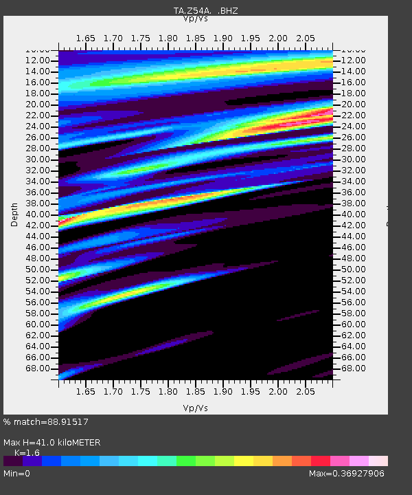
Z54A Sparta, GA, USA - Earthquake Result Viewer
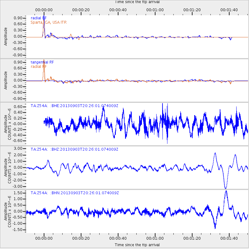
Earthquake location: Queen Charlotte Islands Region
Earthquake latitude/longitude: 51.2/-130.4
Earthquake time(UTC): 2013/09/03 (246) 20:19:06 GMT
Earthquake Depth: 2.7 km
Earthquake Magnitude: 6.1 MWW, 6.0 MWB, 6.1 MWW, 6.1 MWC, 6.2 MI, 6.2 MWC
Earthquake Catalog/Contributor: NEIC PDE/NEIC COMCAT
Network: TA USArray Transportable Network (new EarthScope stations)
Station: Z54A Sparta, GA, USA
Lat/Lon: 33.24 N/82.84 W
Elevation: 134 m
Distance: 38.8 deg
Az: 98.916 deg
Baz: 312.19 deg
Ray Param: 0.07539591
Estimated Moho Depth: 41.0 km
Estimated Crust Vp/Vs: 1.60
Assumed Crust Vp: 6.565 km/s
Estimated Crust Vs: 4.103 km/s
Estimated Crust Poisson's Ratio: 0.18
Radial Match: 88.91517 %
Radial Bump: 400
Transverse Match: 55.059532 %
Transverse Bump: 400
SOD ConfigId: 626651
Insert Time: 2014-04-18 08:49:18.161 +0000
GWidth: 2.5
Max Bumps: 400
Tol: 0.001

Signal To Noise

ChannelStoNSTALTA
TA:Z54A: :BHZ:20130903T20:26:01.074009Z7.44910055.484986E-77.363286E-8
TA:Z54A: :BHN:20130903T20:26:01.074009Z1.5609122.1979358E-71.40811E-7
TA:Z54A: :BHE:20130903T20:26:01.074009Z1.94830162.8001796E-71.4372414E-7
Arrivals
Ps4.1 SECOND
PpPs15 SECOND
PsPs/PpSs19 SECOND