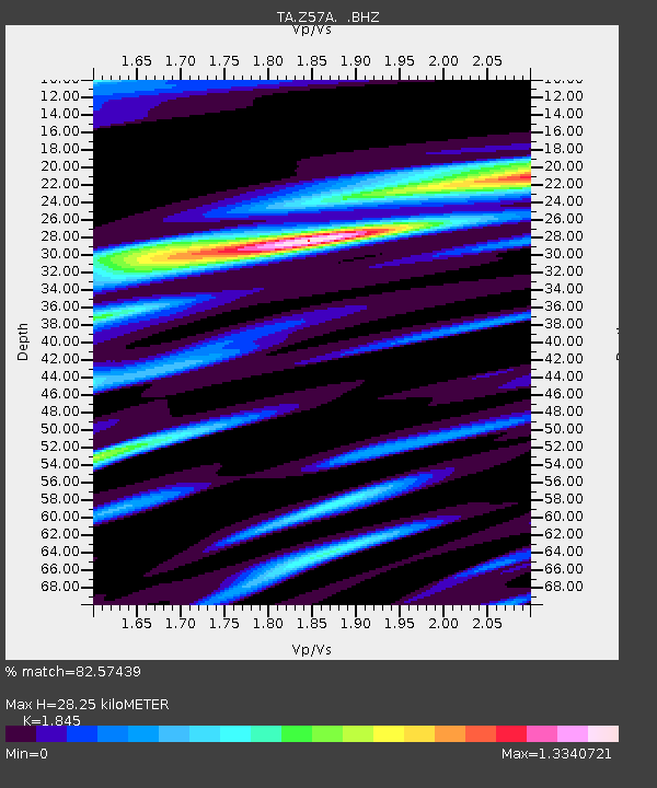
Z57A Bowman, SC, USA - Earthquake Result Viewer

Earthquake location: Queen Charlotte Islands Region
Earthquake latitude/longitude: 51.2/-130.4
Earthquake time(UTC): 2013/09/03 (246) 20:19:06 GMT
Earthquake Depth: 2.7 km
Earthquake Magnitude: 6.1 MWW, 6.0 MWB, 6.1 MWW, 6.1 MWC, 6.2 MI, 6.2 MWC
Earthquake Catalog/Contributor: NEIC PDE/NEIC COMCAT
Network: TA USArray Transportable Network (new EarthScope stations)
Station: Z57A Bowman, SC, USA
Lat/Lon: 33.30 N/80.70 W
Elevation: 81 m
Distance: 40.0 deg
Az: 96.956 deg
Baz: 311.843 deg
Ray Param: 0.07464046
Estimated Moho Depth: 28.25 km
Estimated Crust Vp/Vs: 1.85
Assumed Crust Vp: 6.565 km/s
Estimated Crust Vs: 3.558 km/s
Estimated Crust Poisson's Ratio: 0.29
Radial Match: 82.57439 %
Radial Bump: 400
Transverse Match: 41.95299 %
Transverse Bump: 400
SOD ConfigId: 626651
Insert Time: 2014-04-18 08:49:23.670 +0000
GWidth: 2.5
Max Bumps: 400
Tol: 0.001

Signal To Noise

ChannelStoNSTALTA
TA:Z57A: :BHZ:20130903T20:26:11.824985Z4.0099666.256778E-71.560307E-7
TA:Z57A: :BHN:20130903T20:26:11.824985Z1.26675554.2942185E-73.389935E-7
TA:Z57A: :BHE:20130903T20:26:11.824985Z1.58835825.899016E-73.7139077E-7
Arrivals
Ps3.9 SECOND
PpPs11 SECOND
PsPs/PpSs15 SECOND