ARU Arti, Russia - Earthquake Result Viewer
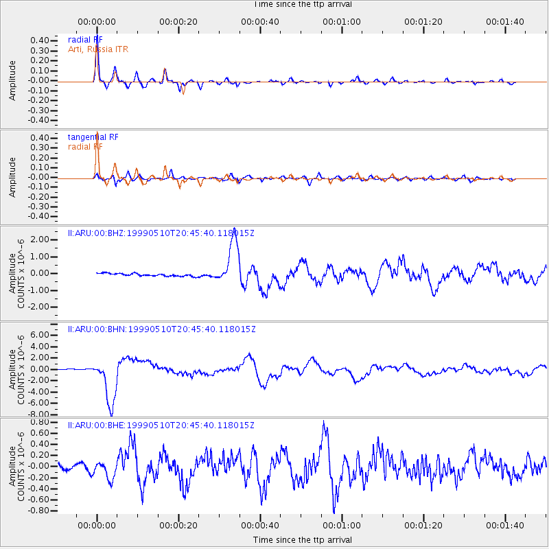
Earthquake location: New Britain Region, P.N.G.
Earthquake latitude/longitude: -5.2/150.9
Earthquake time(UTC): 1999/05/10 (130) 20:33:02 GMT
Earthquake Depth: 138 km
Earthquake Magnitude: 6.5 MB, 6.8 MS, 7.1 MW, 6.5 MB
Earthquake Catalog/Contributor: WHDF/NEIC
Network: II Global Seismograph Network (GSN - IRIS/IDA)
Station: ARU Arti, Russia
Lat/Lon: 56.43 N/58.56 E
Elevation: 250 m
Distance: 95.5 deg
Az: 326.104 deg
Baz: 90.929 deg
Ray Param: 0.04065021
Estimated Moho Depth: 39.25 km
Estimated Crust Vp/Vs: 1.68
Assumed Crust Vp: 6.159 km/s
Estimated Crust Vs: 3.666 km/s
Estimated Crust Poisson's Ratio: 0.23
Radial Match: 96.83244 %
Radial Bump: 247
Transverse Match: 85.31616 %
Transverse Bump: 400
SOD ConfigId: 4480
Insert Time: 2010-03-01 16:29:09.141 +0000
GWidth: 2.5
Max Bumps: 400
Tol: 0.001

Signal To Noise

ChannelStoNSTALTA
II:ARU:00:BHN:19990510T20:45:40.118015Z43.2323654.0960135E-69.4744145E-8
II:ARU:00:BHE:19990510T20:45:40.118015Z2.04979351.5234208E-77.43207E-8
II:ARU:00:BHZ:19990510T20:45:40.118015Z17.3356081.3700044E-67.902835E-8
Arrivals
Ps4.4 SECOND
PpPs17 SECOND
PsPs/PpSs21 SECOND