You are here: Home > Network List > IU - Global Seismograph Network (GSN - IRIS/USGS) Stations List
> Station TEIG Tepich, Yucatan, Mexico > Earthquake Result Viewer
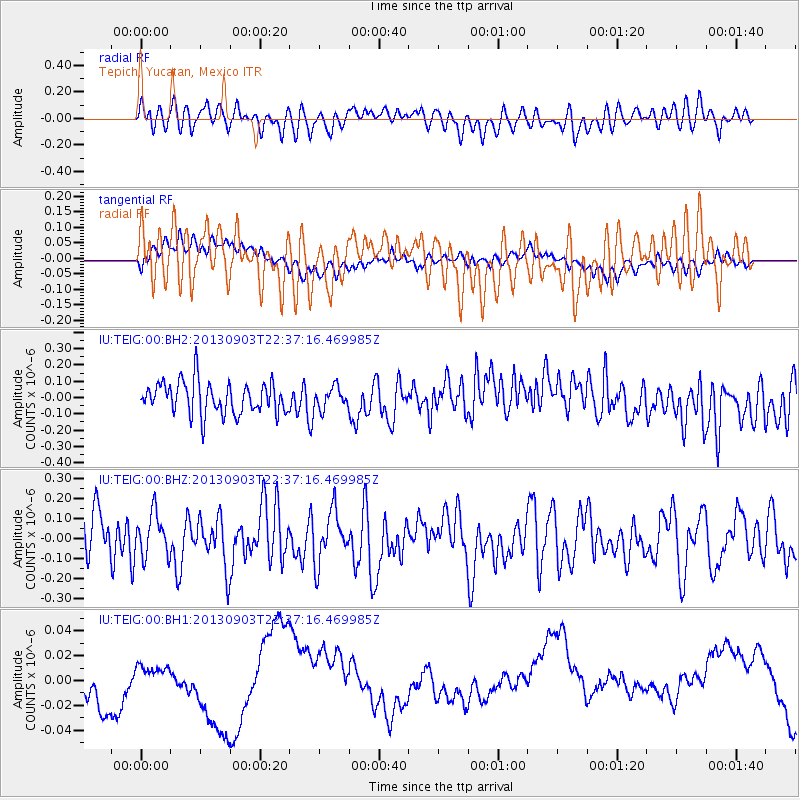
TEIG Tepich, Yucatan, Mexico - Earthquake Result Viewer
*The percent match for this event was below the threshold and hence no stack was calculated.
| Earthquake location: |
Queen Charlotte Islands Region |
| Earthquake latitude/longitude: |
51.3/-130.2 |
| Earthquake time(UTC): |
2013/09/03 (246) 22:29:31 GMT |
| Earthquake Depth: |
9.9 km |
| Earthquake Magnitude: |
5.5 MW, 5.5 MI, 5.5 MWR, 5.5 MWR, 5.5 MWC |
| Earthquake Catalog/Contributor: |
NEIC PDE/NEIC COMCAT |
|
| Network: |
IU Global Seismograph Network (GSN - IRIS/USGS) |
| Station: |
TEIG Tepich, Yucatan, Mexico |
| Lat/Lon: |
20.23 N/88.28 W |
| Elevation: |
40 m |
|
| Distance: |
45.1 deg |
| Az: |
117.609 deg |
| Baz: |
323.698 deg |
| Ray Param: |
$rayparam |
*The percent match for this event was below the threshold and hence was not used in the summary stack. |
|
| Radial Match: |
41.43375 % |
| Radial Bump: |
400 |
| Transverse Match: |
39.465508 % |
| Transverse Bump: |
400 |
| SOD ConfigId: |
626651 |
| Insert Time: |
2014-04-18 08:55:24.165 +0000 |
| GWidth: |
2.5 |
| Max Bumps: |
400 |
| Tol: |
0.001 |
|
Signal To Noise
| Channel | StoN | STA | LTA |
| IU:TEIG:00:BHZ:20130903T22:37:16.469985Z | 0.9257157 | 1.07597586E-7 | 1.1623178E-7 |
| IU:TEIG:00:BH1:20130903T22:37:16.469985Z | 1.4525849 | 1.8614312E-8 | 1.28146125E-8 |
| IU:TEIG:00:BH2:20130903T22:37:16.469985Z | 0.6582153 | 6.437108E-8 | 9.779639E-8 |
| Arrivals |
| Ps | |
| PpPs | |
| PsPs/PpSs | |


