You are here: Home > Network List > TA - USArray Transportable Network (new EarthScope stations) Stations List
> Station W54A Cherokee Point, Campobello, SC, USA > Earthquake Result Viewer
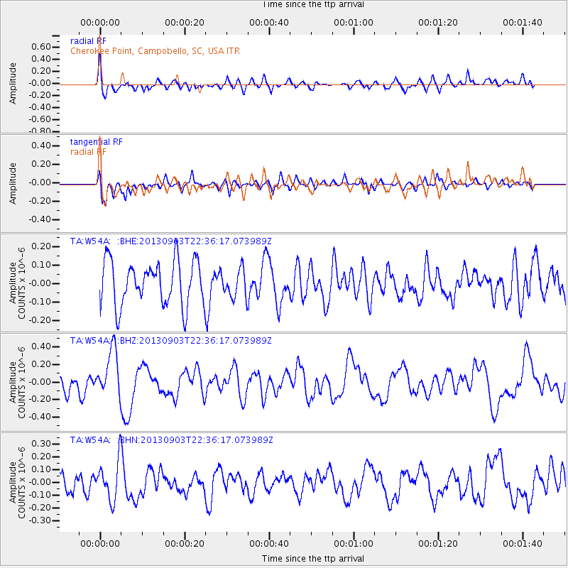
W54A Cherokee Point, Campobello, SC, USA - Earthquake Result Viewer
*The percent match for this event was below the threshold and hence no stack was calculated.
| Earthquake location: |
Queen Charlotte Islands Region |
| Earthquake latitude/longitude: |
51.3/-130.2 |
| Earthquake time(UTC): |
2013/09/03 (246) 22:29:31 GMT |
| Earthquake Depth: |
9.9 km |
| Earthquake Magnitude: |
5.5 MW, 5.5 MI, 5.5 MWR, 5.5 MWR, 5.5 MWC |
| Earthquake Catalog/Contributor: |
NEIC PDE/NEIC COMCAT |
|
| Network: |
TA USArray Transportable Network (new EarthScope stations) |
| Station: |
W54A Cherokee Point, Campobello, SC, USA |
| Lat/Lon: |
35.09 N/82.19 W |
| Elevation: |
272 m |
|
| Distance: |
37.8 deg |
| Az: |
96.364 deg |
| Baz: |
310.506 deg |
| Ray Param: |
$rayparam |
*The percent match for this event was below the threshold and hence was not used in the summary stack. |
|
| Radial Match: |
52.70646 % |
| Radial Bump: |
400 |
| Transverse Match: |
61.31812 % |
| Transverse Bump: |
400 |
| SOD ConfigId: |
626651 |
| Insert Time: |
2014-04-18 09:03:03.457 +0000 |
| GWidth: |
2.5 |
| Max Bumps: |
400 |
| Tol: |
0.001 |
|
Signal To Noise
| Channel | StoN | STA | LTA |
| TA:W54A: :BHZ:20130903T22:36:17.073989Z | 2.4583008 | 2.7421606E-7 | 1.1154698E-7 |
| TA:W54A: :BHN:20130903T22:36:17.073989Z | 2.3887908 | 1.5888365E-7 | 6.6512165E-8 |
| TA:W54A: :BHE:20130903T22:36:17.073989Z | 0.64710253 | 7.7741795E-8 | 1.201383E-7 |
| Arrivals |
| Ps | |
| PpPs | |
| PsPs/PpSs | |


