You are here: Home > Network List > II - Global Seismograph Network (GSN - IRIS/IDA) Stations List
> Station ARU Arti, Russia > Earthquake Result Viewer
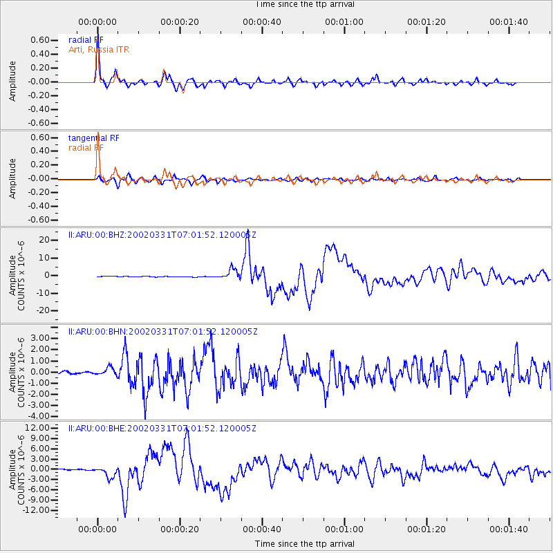
ARU Arti, Russia - Earthquake Result Viewer

| Earthquake location: |
Taiwan Region |
| Earthquake latitude/longitude: |
24.3/122.2 |
| Earthquake time(UTC): |
2002/03/31 (090) 06:52:50 GMT |
| Earthquake Depth: |
33 km |
| Earthquake Magnitude: |
6.4 MB, 7.4 MS, 7.1 MW, 7.1 MW |
| Earthquake Catalog/Contributor: |
WHDF/NEIC |
|
| Network: |
II Global Seismograph Network (GSN - IRIS/IDA) |
| Station: |
ARU Arti, Russia |
| Lat/Lon: |
56.43 N/58.56 E |
| Elevation: |
250 m |
|
| Distance: |
55.6 deg |
| Az: |
322.893 deg |
| Baz: |
97.666 deg |
| Ray Param: |
0.0646428 |
| Estimated Moho Depth: |
40.5 km |
| Estimated Crust Vp/Vs: |
1.63 |
| Assumed Crust Vp: |
6.159 km/s |
| Estimated Crust Vs: |
3.767 km/s |
| Estimated Crust Poisson's Ratio: |
0.20 |
|
| Radial Match: |
98.2594 % |
| Radial Bump: |
397 |
| Transverse Match: |
90.97014 % |
| Transverse Bump: |
400 |
| SOD ConfigId: |
20082 |
| Insert Time: |
2010-03-01 16:29:42.892 +0000 |
| GWidth: |
2.5 |
| Max Bumps: |
400 |
| Tol: |
0.001 |
|
Signal To Noise
| Channel | StoN | STA | LTA |
| II:ARU:00:BHN:20020331T07:01:52.120005Z | 2.574341 | 4.1090445E-7 | 1.596154E-7 |
| II:ARU:00:BHE:20020331T07:01:52.120005Z | 7.149739 | 1.564668E-6 | 2.1884269E-7 |
| II:ARU:00:BHZ:20020331T07:01:52.120005Z | 19.013222 | 3.022216E-6 | 1.589534E-7 |
| Arrivals |
| Ps | 4.4 SECOND |
| PpPs | 16 SECOND |
| PsPs/PpSs | 21 SECOND |


