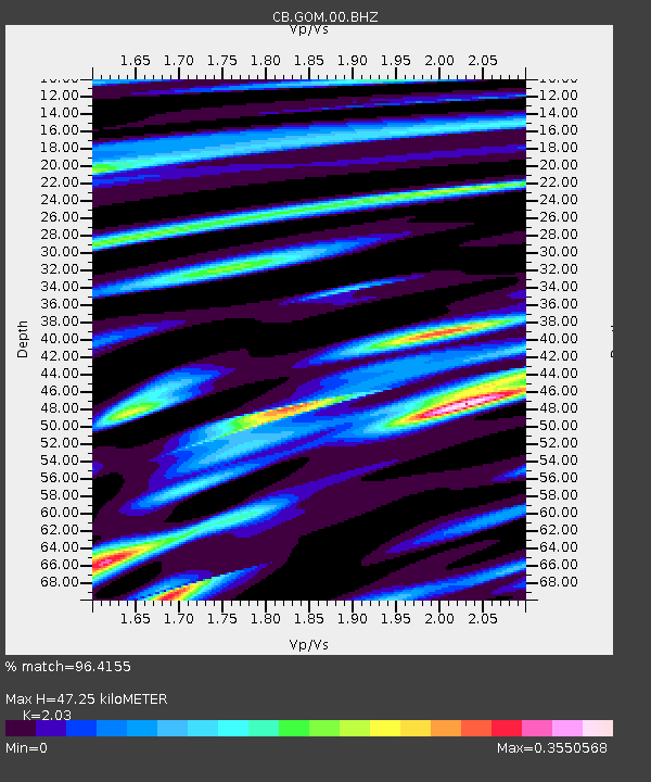
GOM Geermu,Qinghai Province - Earthquake Result Viewer

Earthquake location: Southeast Of Honshu, Japan
Earthquake latitude/longitude: 29.9/138.8
Earthquake time(UTC): 2013/09/04 (247) 00:18:23 GMT
Earthquake Depth: 402 km
Earthquake Magnitude: 6.5 MWW, 6.5 MWW, 6.5 MWB, 6.5 MWC
Earthquake Catalog/Contributor: NEIC PDE/NEIC COMCAT
Network: CB China National Seismic Network
Station: GOM Geermu,Qinghai Province
Lat/Lon: 36.20 N/94.81 E
Elevation: 3121 m
Distance: 37.2 deg
Az: 291.514 deg
Baz: 86.717 deg
Ray Param: 0.074519604
Estimated Moho Depth: 47.25 km
Estimated Crust Vp/Vs: 2.03
Assumed Crust Vp: 6.385 km/s
Estimated Crust Vs: 3.145 km/s
Estimated Crust Poisson's Ratio: 0.34
Radial Match: 96.4155 %
Radial Bump: 238
Transverse Match: 88.87729 %
Transverse Bump: 400
SOD ConfigId: 626651
Insert Time: 2014-04-18 09:11:15.849 +0000
GWidth: 2.5
Max Bumps: 400
Tol: 0.001

Signal To Noise

ChannelStoNSTALTA
CB:GOM:00:BHZ:20130904T00:24:27.489995Z115.228071.2325445E-51.0696565E-7
CB:GOM:00:BHN:20130904T00:24:27.489995Z29.7095531.288679E-64.3375913E-8
CB:GOM:00:BHE:20130904T00:24:27.489995Z108.5990454.749318E-64.3732594E-8
Arrivals
Ps8.1 SECOND
PpPs21 SECOND
PsPs/PpSs29 SECOND