You are here: Home > Network List > CN - Canadian National Seismograph Network Stations List
> Station INK INUVIK, NT > Earthquake Result Viewer
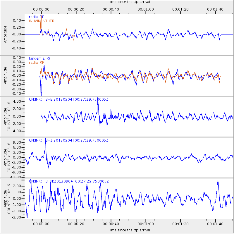
INK INUVIK, NT - Earthquake Result Viewer
*The percent match for this event was below the threshold and hence no stack was calculated.
| Earthquake location: |
Southeast Of Honshu, Japan |
| Earthquake latitude/longitude: |
29.9/138.8 |
| Earthquake time(UTC): |
2013/09/04 (247) 00:18:23 GMT |
| Earthquake Depth: |
402 km |
| Earthquake Magnitude: |
6.5 MWW, 6.5 MWW, 6.5 MWB, 6.5 MWC |
| Earthquake Catalog/Contributor: |
NEIC PDE/NEIC COMCAT |
|
| Network: |
CN Canadian National Seismograph Network |
| Station: |
INK INUVIK, NT |
| Lat/Lon: |
68.31 N/133.53 W |
| Elevation: |
44 m |
|
| Distance: |
61.7 deg |
| Az: |
24.957 deg |
| Baz: |
279.906 deg |
| Ray Param: |
$rayparam |
*The percent match for this event was below the threshold and hence was not used in the summary stack. |
|
| Radial Match: |
55.3066 % |
| Radial Bump: |
400 |
| Transverse Match: |
69.25486 % |
| Transverse Bump: |
400 |
| SOD ConfigId: |
626651 |
| Insert Time: |
2014-04-18 09:13:15.272 +0000 |
| GWidth: |
2.5 |
| Max Bumps: |
400 |
| Tol: |
0.001 |
|
Signal To Noise
| Channel | StoN | STA | LTA |
| CN:INK: :BHZ:20130904T00:27:29.750005Z | 2.2384562 | 3.719185E-6 | 1.6614956E-6 |
| CN:INK: :BHN:20130904T00:27:29.750005Z | 0.8449877 | 1.2270553E-6 | 1.4521577E-6 |
| CN:INK: :BHE:20130904T00:27:29.750005Z | 2.5269246 | 1.7371772E-6 | 6.874669E-7 |
| Arrivals |
| Ps | |
| PpPs | |
| PsPs/PpSs | |


