You are here: Home > Network List > NI - North-East Italy Broadband Network Stations List
> Station CGRP Cima Grappa > Earthquake Result Viewer
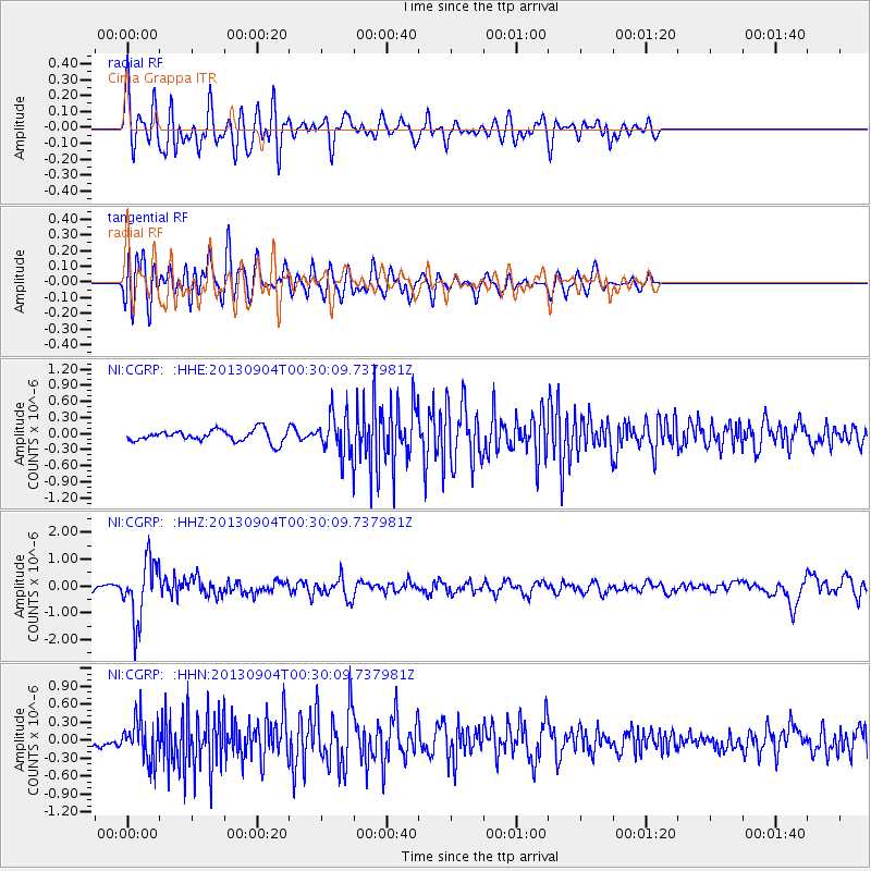
CGRP Cima Grappa - Earthquake Result Viewer
*The percent match for this event was below the threshold and hence no stack was calculated.
| Earthquake location: |
Southeast Of Honshu, Japan |
| Earthquake latitude/longitude: |
29.9/138.8 |
| Earthquake time(UTC): |
2013/09/04 (247) 00:18:23 GMT |
| Earthquake Depth: |
402 km |
| Earthquake Magnitude: |
6.5 MWW, 6.5 MWW, 6.5 MWB, 6.5 MWC |
| Earthquake Catalog/Contributor: |
NEIC PDE/NEIC COMCAT |
|
| Network: |
NI North-East Italy Broadband Network |
| Station: |
CGRP Cima Grappa |
| Lat/Lon: |
45.88 N/11.80 E |
| Elevation: |
1757 m |
|
| Distance: |
90.6 deg |
| Az: |
326.102 deg |
| Baz: |
43.868 deg |
| Ray Param: |
$rayparam |
*The percent match for this event was below the threshold and hence was not used in the summary stack. |
|
| Radial Match: |
72.430626 % |
| Radial Bump: |
400 |
| Transverse Match: |
66.437904 % |
| Transverse Bump: |
400 |
| SOD ConfigId: |
626651 |
| Insert Time: |
2014-04-18 09:20:56.318 +0000 |
| GWidth: |
2.5 |
| Max Bumps: |
400 |
| Tol: |
0.001 |
|
Signal To Noise
| Channel | StoN | STA | LTA |
| NI:CGRP: :HHZ:20130904T00:30:09.737981Z | 9.821269 | 1.1095041E-6 | 1.1296953E-7 |
| NI:CGRP: :HHN:20130904T00:30:09.737981Z | 3.4312627 | 3.5510493E-7 | 1.0349104E-7 |
| NI:CGRP: :HHE:20130904T00:30:09.737981Z | 3.3094702 | 3.6924237E-7 | 1.11571445E-7 |
| Arrivals |
| Ps | |
| PpPs | |
| PsPs/PpSs | |


