You are here: Home > Network List > TA - USArray Transportable Network (new EarthScope stations) Stations List
> Station G59A Clarenceville, QC, USA > Earthquake Result Viewer
G59A Clarenceville, QC, USA - Earthquake Result Viewer
| Earthquake location: |
Off Coast Of Costa Rica |
| Earthquake latitude/longitude: |
10.6/-86.1 |
| Earthquake time(UTC): |
2014/11/16 (320) 10:21:22 GMT |
| Earthquake Depth: |
39 km |
| Earthquake Magnitude: |
5.0 MW, 5.2 mb, 4.3 MS |
| Earthquake Catalog/Contributor: |
ISC/ISC |
|
| Network: |
TA USArray Transportable Network (new EarthScope stations) |
| Station: |
G59A Clarenceville, QC, USA |
| Lat/Lon: |
45.08 N/73.18 W |
| Elevation: |
36 m |
|
| Distance: |
36.2 deg |
| Az: |
15.569 deg |
| Baz: |
201.87 deg |
| Ray Param: |
0.07675249 |
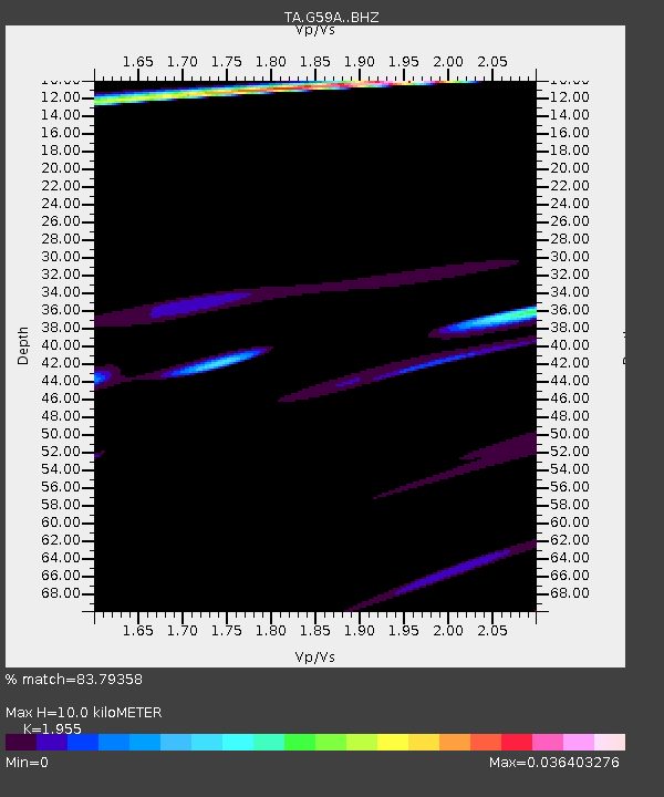
| Estimated Moho Depth: |
10.0 km |
| Estimated Crust Vp/Vs: |
1.96 |
| Assumed Crust Vp: |
6.419 km/s |
| Estimated Crust Vs: |
3.283 km/s |
| Estimated Crust Poisson's Ratio: |
0.32 |
|
| Radial Match: |
83.79358 % |
| Radial Bump: |
172 |
| Transverse Match: |
55.728054 % |
| Transverse Bump: |
236 |
| SOD ConfigId: |
3390531 |
| Insert Time: |
2019-04-15 01:00:12.647 +0000 |
| GWidth: |
2.5 |
| Max Bumps: |
400 |
| Tol: |
0.001 |
|
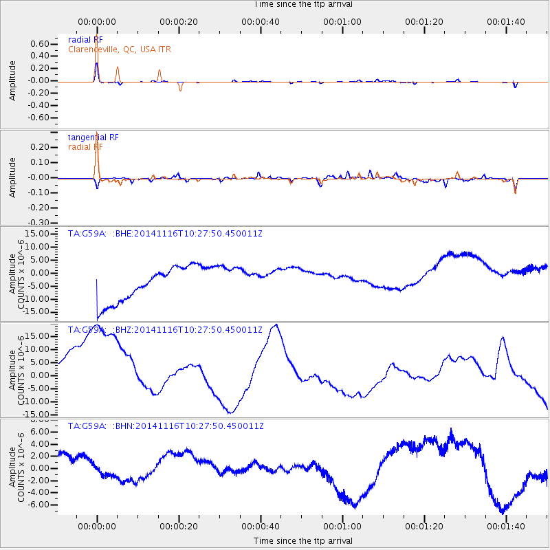
Signal To Noise
| Channel | StoN | STA | LTA |
| TA:G59A: :BHZ:20141116T10:27:50.450011Z | 1.3597385 | 4.3946537E-5 | 3.2319844E-5 |
| TA:G59A: :BHN:20141116T10:27:50.450011Z | 0.5124565 | 3.0450178E-6 | 5.942003E-6 |
| TA:G59A: :BHE:20141116T10:27:50.450011Z | 1.0479205 | 6.8406794E-6 | 6.5278614E-6 |
| Arrivals |
| Ps | 1.6 SECOND |
| PpPs | 4.3 SECOND |
| PsPs/PpSs | 5.9 SECOND |


