You are here: Home > Network List > II - Global Seismograph Network (GSN - IRIS/IDA) Stations List
> Station ARU Arti, Russia > Earthquake Result Viewer
ARU Arti, Russia - Earthquake Result Viewer
| Earthquake location: |
Kuril Islands |
| Earthquake latitude/longitude: |
46.0/151.5 |
| Earthquake time(UTC): |
2009/04/07 (097) 04:23:33 GMT |
| Earthquake Depth: |
31 km |
| Earthquake Magnitude: |
6.5 MB, 6.8 MS, 6.9 MW, 6.9 MW |
| Earthquake Catalog/Contributor: |
WHDF/NEIC |
|
| Network: |
II Global Seismograph Network (GSN - IRIS/IDA) |
| Station: |
ARU Arti, Russia |
| Lat/Lon: |
56.43 N/58.56 E |
| Elevation: |
250 m |
|
| Distance: |
54.8 deg |
| Az: |
317.236 deg |
| Baz: |
58.344 deg |
| Ray Param: |
0.06516645 |
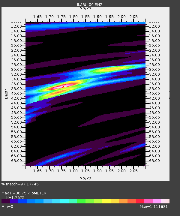
| Estimated Moho Depth: |
36.75 km |
| Estimated Crust Vp/Vs: |
1.76 |
| Assumed Crust Vp: |
6.159 km/s |
| Estimated Crust Vs: |
3.504 km/s |
| Estimated Crust Poisson's Ratio: |
0.26 |
|
| Radial Match: |
97.17745 % |
| Radial Bump: |
329 |
| Transverse Match: |
84.91647 % |
| Transverse Bump: |
400 |
| SOD ConfigId: |
2658 |
| Insert Time: |
2010-03-01 16:30:30.085 +0000 |
| GWidth: |
2.5 |
| Max Bumps: |
400 |
| Tol: |
0.001 |
|

Signal To Noise
| Channel | StoN | STA | LTA |
| II:ARU:00:BHN:20090407T04:32:29.301001Z | 54.96994 | 4.2209913E-6 | 7.6787266E-8 |
| II:ARU:00:BHE:20090407T04:32:29.301001Z | 14.74904 | 1.1611886E-6 | 7.872978E-8 |
| II:ARU:00:BHZ:20090407T04:32:29.301001Z | 19.1617 | 1.962408E-6 | 1.0241305E-7 |
| Arrivals |
| Ps | 4.7 SECOND |
| PpPs | 16 SECOND |
| PsPs/PpSs | 20 SECOND |


