You are here: Home > Network List > TA - USArray Transportable Network (new EarthScope stations) Stations List
> Station J04D Umpqua National Forest, Toketee, OR, USA > Earthquake Result Viewer
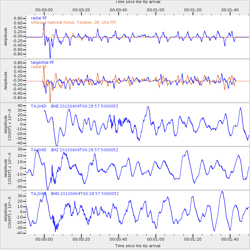
J04D Umpqua National Forest, Toketee, OR, USA - Earthquake Result Viewer
*The percent match for this event was below the threshold and hence no stack was calculated.
| Earthquake location: |
Southeast Of Honshu, Japan |
| Earthquake latitude/longitude: |
29.9/138.8 |
| Earthquake time(UTC): |
2013/09/04 (247) 00:18:23 GMT |
| Earthquake Depth: |
402 km |
| Earthquake Magnitude: |
6.5 MWW, 6.5 MWW, 6.5 MWB, 6.5 MWC |
| Earthquake Catalog/Contributor: |
NEIC PDE/NEIC COMCAT |
|
| Network: |
TA USArray Transportable Network (new EarthScope stations) |
| Station: |
J04D Umpqua National Forest, Toketee, OR, USA |
| Lat/Lon: |
43.24 N/122.11 W |
| Elevation: |
1948 m |
|
| Distance: |
76.2 deg |
| Az: |
48.006 deg |
| Baz: |
298.019 deg |
| Ray Param: |
$rayparam |
*The percent match for this event was below the threshold and hence was not used in the summary stack. |
|
| Radial Match: |
74.17758 % |
| Radial Bump: |
400 |
| Transverse Match: |
55.750355 % |
| Transverse Bump: |
392 |
| SOD ConfigId: |
626651 |
| Insert Time: |
2014-04-18 09:25:00.271 +0000 |
| GWidth: |
2.5 |
| Max Bumps: |
400 |
| Tol: |
0.001 |
|
Signal To Noise
| Channel | StoN | STA | LTA |
| TA:J04D: :BHZ:20130904T00:28:57.500005Z | 1.4168001 | 1.9152863E-5 | 1.3518395E-5 |
| TA:J04D: :BHN:20130904T00:28:57.500005Z | 2.1512187 | 2.3882385E-5 | 1.1101794E-5 |
| TA:J04D: :BHE:20130904T00:28:57.500005Z | 0.5982439 | 1.1247899E-5 | 1.880153E-5 |
| Arrivals |
| Ps | |
| PpPs | |
| PsPs/PpSs | |


