You are here: Home > Network List > TA - USArray Transportable Network (new EarthScope stations) Stations List
> Station N23A Red Feather Lakes, CO, USA > Earthquake Result Viewer
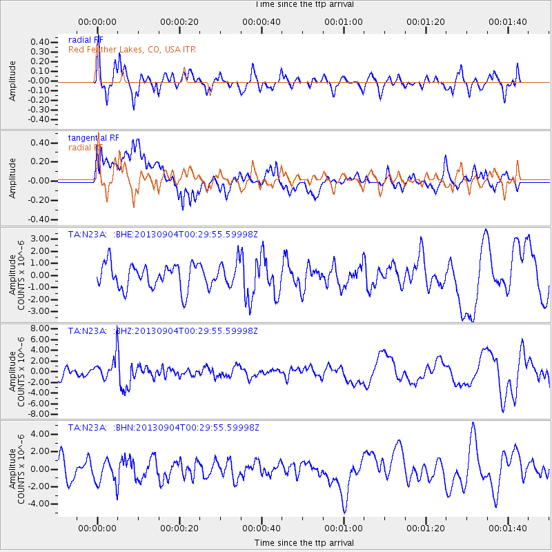
N23A Red Feather Lakes, CO, USA - Earthquake Result Viewer
*The percent match for this event was below the threshold and hence no stack was calculated.
| Earthquake location: |
Southeast Of Honshu, Japan |
| Earthquake latitude/longitude: |
29.9/138.8 |
| Earthquake time(UTC): |
2013/09/04 (247) 00:18:23 GMT |
| Earthquake Depth: |
402 km |
| Earthquake Magnitude: |
6.5 MWW, 6.5 MWW, 6.5 MWB, 6.5 MWC |
| Earthquake Catalog/Contributor: |
NEIC PDE/NEIC COMCAT |
|
| Network: |
TA USArray Transportable Network (new EarthScope stations) |
| Station: |
N23A Red Feather Lakes, CO, USA |
| Lat/Lon: |
40.89 N/105.94 W |
| Elevation: |
2458 m |
|
| Distance: |
87.5 deg |
| Az: |
43.35 deg |
| Baz: |
308.188 deg |
| Ray Param: |
$rayparam |
*The percent match for this event was below the threshold and hence was not used in the summary stack. |
|
| Radial Match: |
70.28178 % |
| Radial Bump: |
400 |
| Transverse Match: |
63.176575 % |
| Transverse Bump: |
400 |
| SOD ConfigId: |
626651 |
| Insert Time: |
2014-04-18 09:25:25.503 +0000 |
| GWidth: |
2.5 |
| Max Bumps: |
400 |
| Tol: |
0.001 |
|
Signal To Noise
| Channel | StoN | STA | LTA |
| TA:N23A: :BHZ:20130904T00:29:55.59998Z | 2.9828408 | 2.2524353E-6 | 7.5513094E-7 |
| TA:N23A: :BHN:20130904T00:29:55.59998Z | 1.3963509 | 1.3359793E-6 | 9.567648E-7 |
| TA:N23A: :BHE:20130904T00:29:55.59998Z | 0.9446896 | 9.849506E-7 | 1.0426184E-6 |
| Arrivals |
| Ps | |
| PpPs | |
| PsPs/PpSs | |


