You are here: Home > Network List > TA - USArray Transportable Network (new EarthScope stations) Stations List
> Station O03E Paynes Creek, CA, USA > Earthquake Result Viewer
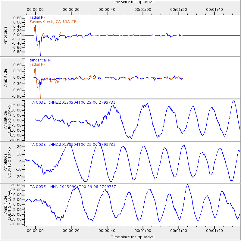
O03E Paynes Creek, CA, USA - Earthquake Result Viewer
*The percent match for this event was below the threshold and hence no stack was calculated.
| Earthquake location: |
Southeast Of Honshu, Japan |
| Earthquake latitude/longitude: |
29.9/138.8 |
| Earthquake time(UTC): |
2013/09/04 (247) 00:18:23 GMT |
| Earthquake Depth: |
402 km |
| Earthquake Magnitude: |
6.5 MWW, 6.5 MWW, 6.5 MWB, 6.5 MWC |
| Earthquake Catalog/Contributor: |
NEIC PDE/NEIC COMCAT |
|
| Network: |
TA USArray Transportable Network (new EarthScope stations) |
| Station: |
O03E Paynes Creek, CA, USA |
| Lat/Lon: |
40.29 N/121.80 W |
| Elevation: |
967 m |
|
| Distance: |
77.8 deg |
| Az: |
50.551 deg |
| Baz: |
298.797 deg |
| Ray Param: |
$rayparam |
*The percent match for this event was below the threshold and hence was not used in the summary stack. |
|
| Radial Match: |
96.20357 % |
| Radial Bump: |
324 |
| Transverse Match: |
72.28539 % |
| Transverse Bump: |
400 |
| SOD ConfigId: |
626651 |
| Insert Time: |
2014-04-18 09:25:34.615 +0000 |
| GWidth: |
2.5 |
| Max Bumps: |
400 |
| Tol: |
0.001 |
|
Signal To Noise
| Channel | StoN | STA | LTA |
| TA:O03E: :HHZ:20130904T00:29:06.279973Z | 3.2174866 | 7.561066E-6 | 2.3499915E-6 |
| TA:O03E: :HHN:20130904T00:29:06.279973Z | 2.018934 | 5.138078E-6 | 2.5449463E-6 |
| TA:O03E: :HHE:20130904T00:29:06.279973Z | 1.857411 | 4.373821E-6 | 2.354794E-6 |
| Arrivals |
| Ps | |
| PpPs | |
| PsPs/PpSs | |


