You are here: Home > Network List > US - United States National Seismic Network Stations List
> Station DUG Dugway, Tooele County, Utah, USA > Earthquake Result Viewer
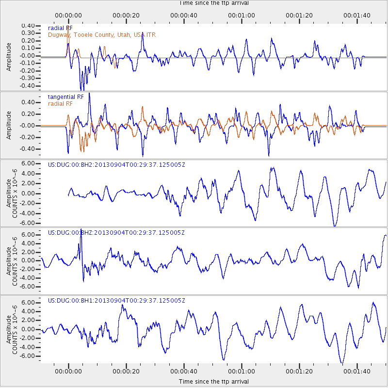
DUG Dugway, Tooele County, Utah, USA - Earthquake Result Viewer
*The percent match for this event was below the threshold and hence no stack was calculated.
| Earthquake location: |
Southeast Of Honshu, Japan |
| Earthquake latitude/longitude: |
29.9/138.8 |
| Earthquake time(UTC): |
2013/09/04 (247) 00:18:23 GMT |
| Earthquake Depth: |
402 km |
| Earthquake Magnitude: |
6.5 MWW, 6.5 MWW, 6.5 MWB, 6.5 MWC |
| Earthquake Catalog/Contributor: |
NEIC PDE/NEIC COMCAT |
|
| Network: |
US United States National Seismic Network |
| Station: |
DUG Dugway, Tooele County, Utah, USA |
| Lat/Lon: |
40.19 N/112.81 W |
| Elevation: |
1477 m |
|
| Distance: |
83.7 deg |
| Az: |
47.008 deg |
| Baz: |
304.017 deg |
| Ray Param: |
$rayparam |
*The percent match for this event was below the threshold and hence was not used in the summary stack. |
|
| Radial Match: |
61.64296 % |
| Radial Bump: |
400 |
| Transverse Match: |
46.32526 % |
| Transverse Bump: |
311 |
| SOD ConfigId: |
626651 |
| Insert Time: |
2014-04-18 09:26:24.455 +0000 |
| GWidth: |
2.5 |
| Max Bumps: |
400 |
| Tol: |
0.001 |
|
Signal To Noise
| Channel | StoN | STA | LTA |
| US:DUG:00:BHZ:20130904T00:29:37.125005Z | 3.7665372 | 2.272445E-6 | 6.0332474E-7 |
| US:DUG:00:BH1:20130904T00:29:37.125005Z | 1.2421404 | 7.429109E-7 | 5.9808934E-7 |
| US:DUG:00:BH2:20130904T00:29:37.125005Z | 1.3374418 | 8.722049E-7 | 6.521442E-7 |
| Arrivals |
| Ps | |
| PpPs | |
| PsPs/PpSs | |


