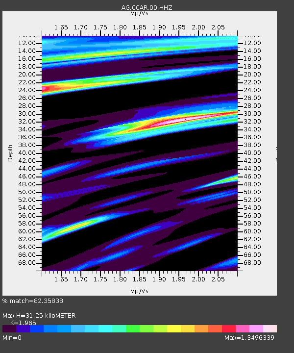
CCAR Cane Creek, AR - Earthquake Result Viewer

Earthquake location: Queen Charlotte Islands Region
Earthquake latitude/longitude: 51.2/-130.2
Earthquake time(UTC): 2013/09/04 (247) 00:23:11 GMT
Earthquake Depth: 9.9 km
Earthquake Magnitude: 6.0 MW, 5.9 MI, 5.9 MWR, 6.0 MWW, 6.0 MWW, 6.0 MWC
Earthquake Catalog/Contributor: NEIC PDE/NEIC COMCAT
Network: AG Arkansas Seismic Network
Station: CCAR Cane Creek, AR
Lat/Lon: 33.92 N/91.77 W
Elevation: 72 m
Distance: 32.7 deg
Az: 106.837 deg
Baz: 313.58 deg
Ray Param: 0.07853909
Estimated Moho Depth: 31.25 km
Estimated Crust Vp/Vs: 1.97
Assumed Crust Vp: 6.201 km/s
Estimated Crust Vs: 3.156 km/s
Estimated Crust Poisson's Ratio: 0.33
Radial Match: 82.35838 %
Radial Bump: 364
Transverse Match: 59.92282 %
Transverse Bump: 400
SOD ConfigId: 626651
Insert Time: 2014-04-18 09:29:12.443 +0000
GWidth: 2.5
Max Bumps: 400
Tol: 0.001

Signal To Noise

ChannelStoNSTALTA
AG:CCAR:00:HHZ:20130904T00:29:13.085013Z3.09895949.089134E-72.9329632E-7
AG:CCAR:00:HHN:20130904T00:29:13.085013Z0.887055646.9680425E-77.8552483E-7
AG:CCAR:00:HHE:20130904T00:29:13.085013Z1.20933966.3631586E-75.2616804E-7
Arrivals
Ps5.2 SECOND
PpPs14 SECOND
PsPs/PpSs19 SECOND