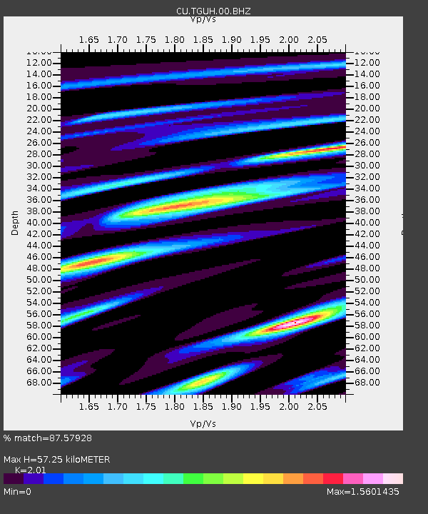
TGUH Tegucigalpa, Honduras - Earthquake Result Viewer

Earthquake location: Queen Charlotte Islands Region
Earthquake latitude/longitude: 51.2/-130.2
Earthquake time(UTC): 2013/09/04 (247) 00:23:11 GMT
Earthquake Depth: 9.9 km
Earthquake Magnitude: 6.0 MW, 5.9 MI, 5.9 MWR, 6.0 MWW, 6.0 MWW, 6.0 MWC
Earthquake Catalog/Contributor: NEIC PDE/NEIC COMCAT
Network: CU Caribbean Network (USGS)
Station: TGUH Tegucigalpa, Honduras
Lat/Lon: 14.06 N/87.27 W
Elevation: 0.0 m
Distance: 50.6 deg
Az: 121.175 deg
Baz: 326.296 deg
Ray Param: 0.067941934
Estimated Moho Depth: 57.25 km
Estimated Crust Vp/Vs: 2.01
Assumed Crust Vp: 6.597 km/s
Estimated Crust Vs: 3.282 km/s
Estimated Crust Poisson's Ratio: 0.34
Radial Match: 87.57928 %
Radial Bump: 400
Transverse Match: 73.874695 %
Transverse Bump: 400
SOD ConfigId: 626651
Insert Time: 2014-04-18 09:30:42.034 +0000
GWidth: 2.5
Max Bumps: 400
Tol: 0.001

Signal To Noise

ChannelStoNSTALTA
CU:TGUH:00:BHZ:20130904T00:31:39.299003Z4.7579514.973866E-71.04537996E-7
CU:TGUH:00:BH1:20130904T00:31:39.299003Z2.69603682.2497882E-78.344798E-8
CU:TGUH:00:BH2:20130904T00:31:39.299003Z2.21820331.6296731E-77.346816E-8
Arrivals
Ps9.2 SECOND
PpPs25 SECOND
PsPs/PpSs34 SECOND