You are here: Home > Network List > IU - Global Seismograph Network (GSN - IRIS/USGS) Stations List
> Station TEIG Tepich, Yucatan, Mexico > Earthquake Result Viewer
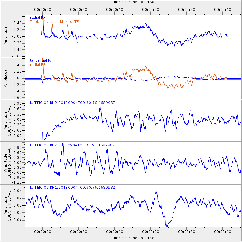
TEIG Tepich, Yucatan, Mexico - Earthquake Result Viewer
*The percent match for this event was below the threshold and hence no stack was calculated.
| Earthquake location: |
Queen Charlotte Islands Region |
| Earthquake latitude/longitude: |
51.2/-130.2 |
| Earthquake time(UTC): |
2013/09/04 (247) 00:23:11 GMT |
| Earthquake Depth: |
9.9 km |
| Earthquake Magnitude: |
6.0 MW, 5.9 MI, 5.9 MWR, 6.0 MWW, 6.0 MWW, 6.0 MWC |
| Earthquake Catalog/Contributor: |
NEIC PDE/NEIC COMCAT |
|
| Network: |
IU Global Seismograph Network (GSN - IRIS/USGS) |
| Station: |
TEIG Tepich, Yucatan, Mexico |
| Lat/Lon: |
20.23 N/88.28 W |
| Elevation: |
40 m |
|
| Distance: |
45.0 deg |
| Az: |
117.476 deg |
| Baz: |
323.515 deg |
| Ray Param: |
$rayparam |
*The percent match for this event was below the threshold and hence was not used in the summary stack. |
|
| Radial Match: |
66.146255 % |
| Radial Bump: |
400 |
| Transverse Match: |
65.73921 % |
| Transverse Bump: |
400 |
| SOD ConfigId: |
626651 |
| Insert Time: |
2014-04-18 09:33:37.535 +0000 |
| GWidth: |
2.5 |
| Max Bumps: |
400 |
| Tol: |
0.001 |
|
Signal To Noise
| Channel | StoN | STA | LTA |
| IU:TEIG:00:BHZ:20130904T00:30:56.168998Z | 3.7313418 | 3.6797067E-7 | 9.861618E-8 |
| IU:TEIG:00:BH1:20130904T00:30:56.168998Z | 1.1401613 | 1.1007941E-8 | 9.654723E-9 |
| IU:TEIG:00:BH2:20130904T00:30:56.168998Z | 1.1330101 | 4.7834754E-7 | 4.2219176E-7 |
| Arrivals |
| Ps | |
| PpPs | |
| PsPs/PpSs | |


