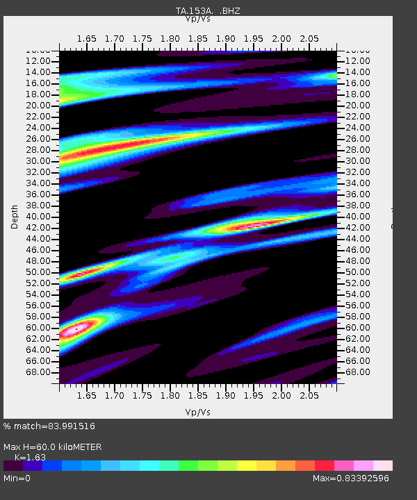
153A Fort Valley, GA, USA - Earthquake Result Viewer
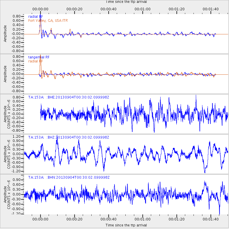
Earthquake location: Queen Charlotte Islands Region
Earthquake latitude/longitude: 51.2/-130.2
Earthquake time(UTC): 2013/09/04 (247) 00:23:11 GMT
Earthquake Depth: 9.9 km
Earthquake Magnitude: 6.0 MW, 5.9 MI, 5.9 MWR, 6.0 MWW, 6.0 MWW, 6.0 MWC
Earthquake Catalog/Contributor: NEIC PDE/NEIC COMCAT
Network: TA USArray Transportable Network (new EarthScope stations)
Station: 153A Fort Valley, GA, USA
Lat/Lon: 32.66 N/83.83 W
Elevation: 160 m
Distance: 38.4 deg
Az: 100.579 deg
Baz: 312.823 deg
Ray Param: 0.07557558
Estimated Moho Depth: 60.0 km
Estimated Crust Vp/Vs: 1.63
Assumed Crust Vp: 6.565 km/s
Estimated Crust Vs: 4.027 km/s
Estimated Crust Poisson's Ratio: 0.20
Radial Match: 83.991516 %
Radial Bump: 400
Transverse Match: 54.240482 %
Transverse Bump: 400
SOD ConfigId: 626651
Insert Time: 2014-04-18 09:38:14.619 +0000
GWidth: 2.5
Max Bumps: 400
Tol: 0.001

Signal To Noise

ChannelStoNSTALTA
TA:153A: :BHZ:20130904T00:30:02.099998Z3.100643.2834842E-71.0589698E-7
TA:153A: :BHN:20130904T00:30:02.099998Z1.07487941.5198361E-71.4139597E-7
TA:153A: :BHE:20130904T00:30:02.099998Z1.56586522.220091E-71.4178048E-7
Arrivals
Ps6.3 SECOND
PpPs22 SECOND
PsPs/PpSs28 SECOND