You are here: Home > Network List > TA - USArray Transportable Network (new EarthScope stations) Stations List
> Station 353A Camilla, GA, USA > Earthquake Result Viewer
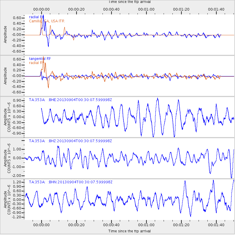
353A Camilla, GA, USA - Earthquake Result Viewer
*The percent match for this event was below the threshold and hence no stack was calculated.
| Earthquake location: |
Queen Charlotte Islands Region |
| Earthquake latitude/longitude: |
51.2/-130.2 |
| Earthquake time(UTC): |
2013/09/04 (247) 00:23:11 GMT |
| Earthquake Depth: |
9.9 km |
| Earthquake Magnitude: |
6.0 MW, 5.9 MI, 5.9 MWR, 6.0 MWW, 6.0 MWW, 6.0 MWC |
| Earthquake Catalog/Contributor: |
NEIC PDE/NEIC COMCAT |
|
| Network: |
TA USArray Transportable Network (new EarthScope stations) |
| Station: |
353A Camilla, GA, USA |
| Lat/Lon: |
31.35 N/84.22 W |
| Elevation: |
54 m |
|
| Distance: |
39.1 deg |
| Az: |
102.457 deg |
| Baz: |
314.085 deg |
| Ray Param: |
$rayparam |
*The percent match for this event was below the threshold and hence was not used in the summary stack. |
|
| Radial Match: |
75.874 % |
| Radial Bump: |
352 |
| Transverse Match: |
37.981365 % |
| Transverse Bump: |
400 |
| SOD ConfigId: |
626651 |
| Insert Time: |
2014-04-18 09:38:38.627 +0000 |
| GWidth: |
2.5 |
| Max Bumps: |
400 |
| Tol: |
0.001 |
|
Signal To Noise
| Channel | StoN | STA | LTA |
| TA:353A: :BHZ:20130904T00:30:07.599998Z | 2.52513 | 4.7333003E-7 | 1.8744778E-7 |
| TA:353A: :BHN:20130904T00:30:07.599998Z | 0.9674018 | 2.5119533E-7 | 2.5965977E-7 |
| TA:353A: :BHE:20130904T00:30:07.599998Z | 1.7857667 | 3.6789916E-7 | 2.0601748E-7 |
| Arrivals |
| Ps | |
| PpPs | |
| PsPs/PpSs | |


