You are here: Home > Network List > CI - Caltech Regional Seismic Network Stations List
> Station TIN Tinemaha, California, USA > Earthquake Result Viewer
TIN Tinemaha, California, USA - Earthquake Result Viewer
| Earthquake location: |
Near Coast Of Chiapas, Mexico |
| Earthquake latitude/longitude: |
15.6/-93.1 |
| Earthquake time(UTC): |
2001/11/28 (332) 14:32:32 GMT |
| Earthquake Depth: |
85 km |
| Earthquake Magnitude: |
5.7 MB, 6.4 MW, 6.4 MW |
| Earthquake Catalog/Contributor: |
WHDF/NEIC |
|
| Network: |
CI Caltech Regional Seismic Network |
| Station: |
TIN Tinemaha, California, USA |
| Lat/Lon: |
37.05 N/118.23 W |
| Elevation: |
1164 m |
|
| Distance: |
30.9 deg |
| Az: |
318.582 deg |
| Baz: |
127.159 deg |
| Ray Param: |
0.07907909 |
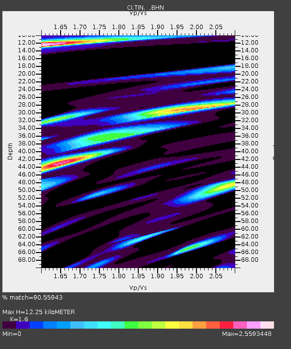
| Estimated Moho Depth: |
12.25 km |
| Estimated Crust Vp/Vs: |
1.60 |
| Assumed Crust Vp: |
6.291 km/s |
| Estimated Crust Vs: |
3.932 km/s |
| Estimated Crust Poisson's Ratio: |
0.18 |
|
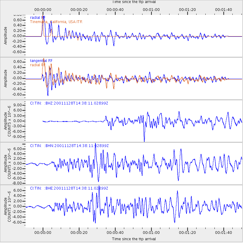
| Radial Match: |
90.55943 % |
| Radial Bump: |
400 |
| Transverse Match: |
82.68331 % |
| Transverse Bump: |
400 |
| SOD ConfigId: |
3787 |
| Insert Time: |
2010-02-25 20:51:27.499 +0000 |
| GWidth: |
2.5 |
| Max Bumps: |
400 |
| Tol: |
0.001 |
|
Signal To Noise
| Channel | StoN | STA | LTA |
| CI:TIN: :BHN:20011128T14:38:11.02899Z | 1.0228499 | 2.6881048E-7 | 2.628054E-7 |
| CI:TIN: :BHE:20011128T14:38:11.02899Z | 1.6653979 | 3.290312E-7 | 1.9756912E-7 |
| CI:TIN: :BHZ:20011128T14:38:11.02899Z | 4.210032 | 6.432949E-7 | 1.528005E-7 |
| Arrivals |
| Ps | 1.3 SECOND |
| PpPs | 4.7 SECOND |
| PsPs/PpSs | 5.9 SECOND |


