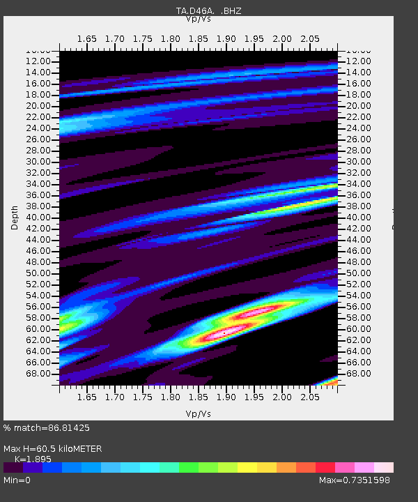
D46A Sault St. Marie, ON, CAN - Earthquake Result Viewer

Earthquake location: Queen Charlotte Islands Region
Earthquake latitude/longitude: 51.2/-130.2
Earthquake time(UTC): 2013/09/04 (247) 00:23:11 GMT
Earthquake Depth: 9.9 km
Earthquake Magnitude: 6.0 MW, 5.9 MI, 5.9 MWR, 6.0 MWW, 6.0 MWW, 6.0 MWC
Earthquake Catalog/Contributor: NEIC PDE/NEIC COMCAT
Network: TA USArray Transportable Network (new EarthScope stations)
Station: D46A Sault St. Marie, ON, CAN
Lat/Lon: 46.89 N/84.04 W
Elevation: 353 m
Distance: 30.2 deg
Az: 79.796 deg
Baz: 295.42 deg
Ray Param: 0.07939737
Estimated Moho Depth: 60.5 km
Estimated Crust Vp/Vs: 1.89
Assumed Crust Vp: 6.467 km/s
Estimated Crust Vs: 3.412 km/s
Estimated Crust Poisson's Ratio: 0.31
Radial Match: 86.81425 %
Radial Bump: 370
Transverse Match: 60.761894 %
Transverse Bump: 400
SOD ConfigId: 626651
Insert Time: 2014-04-18 09:39:04.084 +0000
GWidth: 2.5
Max Bumps: 400
Tol: 0.001

Signal To Noise

ChannelStoNSTALTA
TA:D46A: :BHZ:20130904T00:28:51.024985Z3.27775555.3485496E-71.6317719E-7
TA:D46A: :BHN:20130904T00:28:51.024985Z1.73824182.3473389E-71.3504099E-7
TA:D46A: :BHE:20130904T00:28:51.024985Z1.33702111.9061108E-71.4256399E-7
Arrivals
Ps9.0 SECOND
PpPs25 SECOND
PsPs/PpSs34 SECOND