You are here: Home > Network List > TA - USArray Transportable Network (new EarthScope stations) Stations List
> Station I46A Reed City, MI, USA > Earthquake Result Viewer
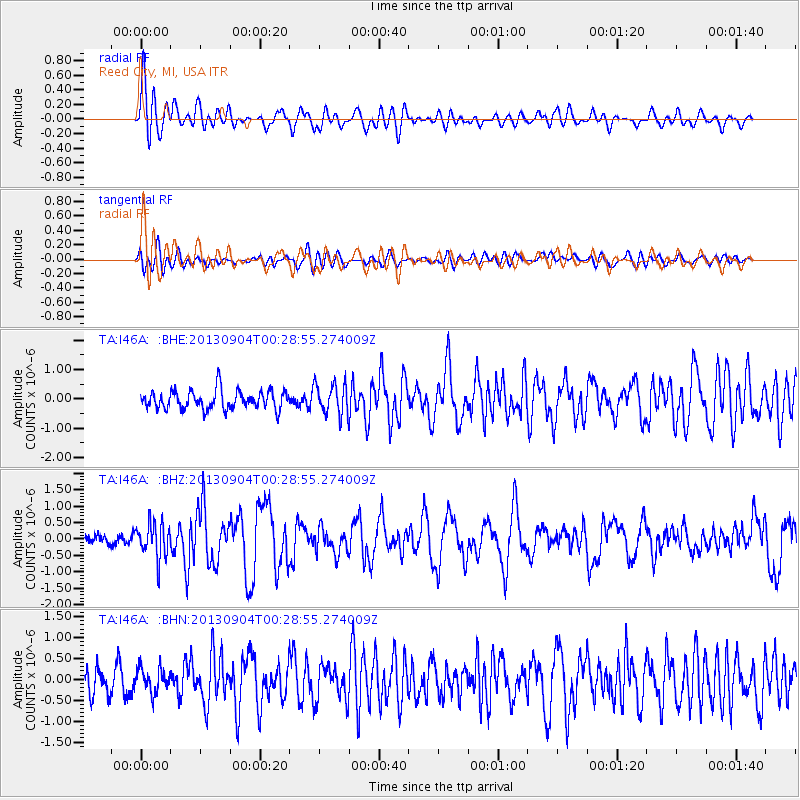
I46A Reed City, MI, USA - Earthquake Result Viewer
*The percent match for this event was below the threshold and hence no stack was calculated.
| Earthquake location: |
Queen Charlotte Islands Region |
| Earthquake latitude/longitude: |
51.2/-130.2 |
| Earthquake time(UTC): |
2013/09/04 (247) 00:23:11 GMT |
| Earthquake Depth: |
9.9 km |
| Earthquake Magnitude: |
6.0 MW, 5.9 MI, 5.9 MWR, 6.0 MWW, 6.0 MWW, 6.0 MWC |
| Earthquake Catalog/Contributor: |
NEIC PDE/NEIC COMCAT |
|
| Network: |
TA USArray Transportable Network (new EarthScope stations) |
| Station: |
I46A Reed City, MI, USA |
| Lat/Lon: |
43.94 N/85.45 W |
| Elevation: |
359 m |
|
| Distance: |
30.7 deg |
| Az: |
85.87 deg |
| Baz: |
299.656 deg |
| Ray Param: |
$rayparam |
*The percent match for this event was below the threshold and hence was not used in the summary stack. |
|
| Radial Match: |
75.84991 % |
| Radial Bump: |
400 |
| Transverse Match: |
50.145477 % |
| Transverse Bump: |
400 |
| SOD ConfigId: |
626651 |
| Insert Time: |
2014-04-18 09:40:02.962 +0000 |
| GWidth: |
2.5 |
| Max Bumps: |
400 |
| Tol: |
0.001 |
|
Signal To Noise
| Channel | StoN | STA | LTA |
| TA:I46A: :BHZ:20130904T00:28:55.274009Z | 3.0411813 | 5.3304484E-7 | 1.7527557E-7 |
| TA:I46A: :BHN:20130904T00:28:55.274009Z | 0.72480917 | 2.8041316E-7 | 3.868786E-7 |
| TA:I46A: :BHE:20130904T00:28:55.274009Z | 1.6908923 | 5.3211835E-7 | 3.1469676E-7 |
| Arrivals |
| Ps | |
| PpPs | |
| PsPs/PpSs | |


