You are here: Home > Network List > KN - Kyrgyz Seismic Telemetry Network Stations List
> Station TKM2 - > Earthquake Result Viewer
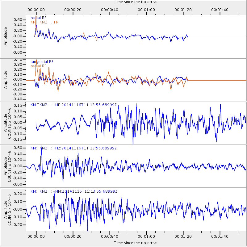
TKM2 - - Earthquake Result Viewer
*The percent match for this event was below the threshold and hence no stack was calculated.
| Earthquake location: |
Northern Sumatra, Indonesia |
| Earthquake latitude/longitude: |
1.6/97.9 |
| Earthquake time(UTC): |
2014/11/16 (320) 11:06:09 GMT |
| Earthquake Depth: |
46 km |
| Earthquake Magnitude: |
5.4 MW, 5.3 mb, 4.6 MS |
| Earthquake Catalog/Contributor: |
ISC/ISC |
|
| Network: |
KN Kyrgyz Seismic Telemetry Network |
| Station: |
TKM2 - |
| Lat/Lon: |
42.92 N/75.60 E |
| Elevation: |
2020 m |
|
| Distance: |
45.7 deg |
| Az: |
337.063 deg |
| Baz: |
147.973 deg |
| Ray Param: |
$rayparam |
*The percent match for this event was below the threshold and hence was not used in the summary stack. |
|
| Radial Match: |
65.05023 % |
| Radial Bump: |
400 |
| Transverse Match: |
54.790466 % |
| Transverse Bump: |
400 |
| SOD ConfigId: |
3390531 |
| Insert Time: |
2019-04-15 01:04:29.434 +0000 |
| GWidth: |
2.5 |
| Max Bumps: |
400 |
| Tol: |
0.001 |
|
Signal To Noise
| Channel | StoN | STA | LTA |
| KN:TKM2: :HHZ:20141116T11:13:55.68999Z | 6.304263 | 2.2126706E-7 | 3.5098008E-8 |
| KN:TKM2: :HHN:20141116T11:13:55.68999Z | 1.8912795 | 6.786613E-8 | 3.5883716E-8 |
| KN:TKM2: :HHE:20141116T11:13:55.68999Z | 2.1541028 | 7.0052664E-8 | 3.252058E-8 |
| Arrivals |
| Ps | |
| PpPs | |
| PsPs/PpSs | |


