You are here: Home > Network List > TA - USArray Transportable Network (new EarthScope stations) Stations List
> Station N60A Cedar Hill Farm, Mount Bethel, PA, USA > Earthquake Result Viewer
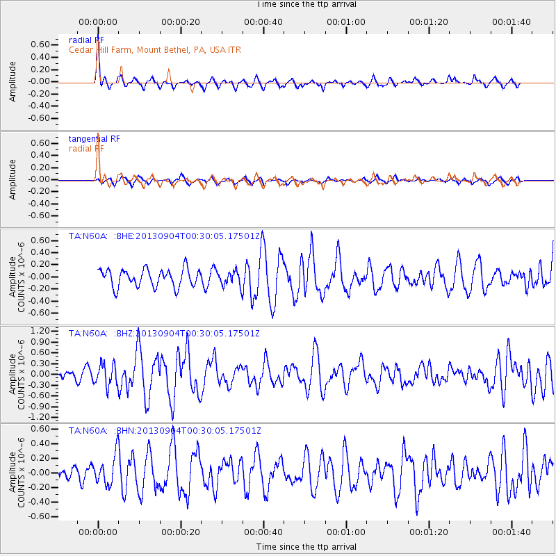
N60A Cedar Hill Farm, Mount Bethel, PA, USA - Earthquake Result Viewer
*The percent match for this event was below the threshold and hence no stack was calculated.
| Earthquake location: |
Queen Charlotte Islands Region |
| Earthquake latitude/longitude: |
51.2/-130.2 |
| Earthquake time(UTC): |
2013/09/04 (247) 00:23:11 GMT |
| Earthquake Depth: |
9.9 km |
| Earthquake Magnitude: |
6.0 MW, 5.9 MI, 5.9 MWR, 6.0 MWW, 6.0 MWW, 6.0 MWC |
| Earthquake Catalog/Contributor: |
NEIC PDE/NEIC COMCAT |
|
| Network: |
TA USArray Transportable Network (new EarthScope stations) |
| Station: |
N60A Cedar Hill Farm, Mount Bethel, PA, USA |
| Lat/Lon: |
40.87 N/75.10 W |
| Elevation: |
189 m |
|
| Distance: |
38.8 deg |
| Az: |
83.282 deg |
| Baz: |
304.489 deg |
| Ray Param: |
$rayparam |
*The percent match for this event was below the threshold and hence was not used in the summary stack. |
|
| Radial Match: |
76.6732 % |
| Radial Bump: |
332 |
| Transverse Match: |
51.728996 % |
| Transverse Bump: |
334 |
| SOD ConfigId: |
626651 |
| Insert Time: |
2014-04-18 09:41:26.113 +0000 |
| GWidth: |
2.5 |
| Max Bumps: |
400 |
| Tol: |
0.001 |
|
Signal To Noise
| Channel | StoN | STA | LTA |
| TA:N60A: :BHZ:20130904T00:30:05.17501Z | 3.1031883 | 3.1159703E-7 | 1.004119E-7 |
| TA:N60A: :BHN:20130904T00:30:05.17501Z | 2.8230622 | 2.0952162E-7 | 7.421785E-8 |
| TA:N60A: :BHE:20130904T00:30:05.17501Z | 0.8452733 | 1.2160987E-7 | 1.4387048E-7 |
| Arrivals |
| Ps | |
| PpPs | |
| PsPs/PpSs | |


