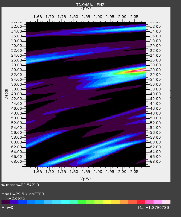
O48A Farmland, IN, USA - Earthquake Result Viewer
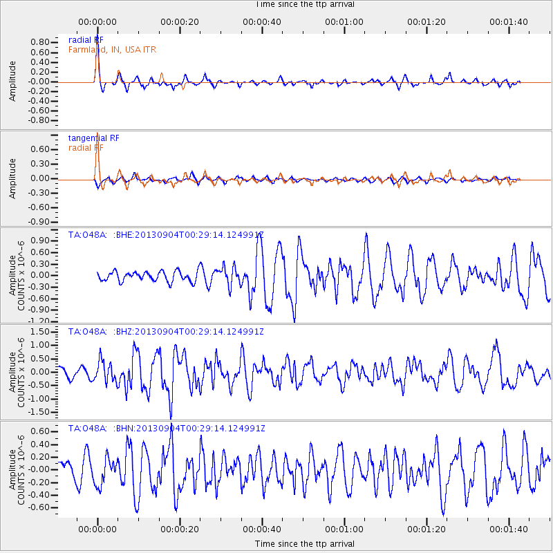
Earthquake location: Queen Charlotte Islands Region
Earthquake latitude/longitude: 51.2/-130.2
Earthquake time(UTC): 2013/09/04 (247) 00:23:11 GMT
Earthquake Depth: 9.9 km
Earthquake Magnitude: 6.0 MW, 5.9 MI, 5.9 MWR, 6.0 MWW, 6.0 MWW, 6.0 MWC
Earthquake Catalog/Contributor: NEIC PDE/NEIC COMCAT
Network: TA USArray Transportable Network (new EarthScope stations)
Station: O48A Farmland, IN, USA
Lat/Lon: 40.26 N/85.16 W
Elevation: 300 m
Distance: 32.8 deg
Az: 91.573 deg
Baz: 304.704 deg
Ray Param: 0.0784896
Estimated Moho Depth: 29.5 km
Estimated Crust Vp/Vs: 2.10
Assumed Crust Vp: 6.498 km/s
Estimated Crust Vs: 3.098 km/s
Estimated Crust Poisson's Ratio: 0.35
Radial Match: 83.54219 %
Radial Bump: 292
Transverse Match: 63.345486 %
Transverse Bump: 400
SOD ConfigId: 626651
Insert Time: 2014-04-18 09:41:30.100 +0000
GWidth: 2.5
Max Bumps: 400
Tol: 0.001

Signal To Noise

ChannelStoNSTALTA
TA:O48A: :BHZ:20130904T00:29:14.124991Z2.29399133.9258822E-71.7113763E-7
TA:O48A: :BHN:20130904T00:29:14.124991Z1.30835882.1000797E-71.6051253E-7
TA:O48A: :BHE:20130904T00:29:14.124991Z1.87866812.395967E-71.275354E-7
Arrivals
Ps5.3 SECOND
PpPs13 SECOND
PsPs/PpSs18 SECOND