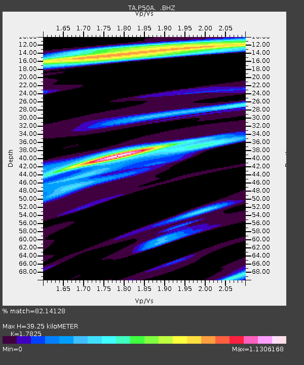
P50A Jamestown, OH, USA - Earthquake Result Viewer

Earthquake location: Queen Charlotte Islands Region
Earthquake latitude/longitude: 51.2/-130.2
Earthquake time(UTC): 2013/09/04 (247) 00:23:11 GMT
Earthquake Depth: 9.9 km
Earthquake Magnitude: 6.0 MW, 5.9 MI, 5.9 MWR, 6.0 MWW, 6.0 MWW, 6.0 MWC
Earthquake Catalog/Contributor: NEIC PDE/NEIC COMCAT
Network: TA USArray Transportable Network (new EarthScope stations)
Station: P50A Jamestown, OH, USA
Lat/Lon: 39.61 N/83.80 W
Elevation: 318 m
Distance: 34.0 deg
Az: 91.447 deg
Baz: 305.466 deg
Ray Param: 0.07792803
Estimated Moho Depth: 39.25 km
Estimated Crust Vp/Vs: 1.78
Assumed Crust Vp: 6.232 km/s
Estimated Crust Vs: 3.496 km/s
Estimated Crust Poisson's Ratio: 0.27
Radial Match: 82.14128 %
Radial Bump: 400
Transverse Match: 57.21888 %
Transverse Bump: 400
SOD ConfigId: 626651
Insert Time: 2014-04-18 09:41:50.378 +0000
GWidth: 2.5
Max Bumps: 400
Tol: 0.001

Signal To Noise

ChannelStoNSTALTA
TA:P50A: :BHZ:20130904T00:29:24.774985Z1.84170212.6586878E-71.4436037E-7
TA:P50A: :BHN:20130904T00:29:24.774985Z0.90904121.2683935E-71.3953091E-7
TA:P50A: :BHE:20130904T00:29:24.774985Z1.0430471.316666E-71.2623266E-7
Arrivals
Ps5.3 SECOND
PpPs16 SECOND
PsPs/PpSs22 SECOND