Q54A Coxs Mills, WV, USA - Earthquake Result Viewer
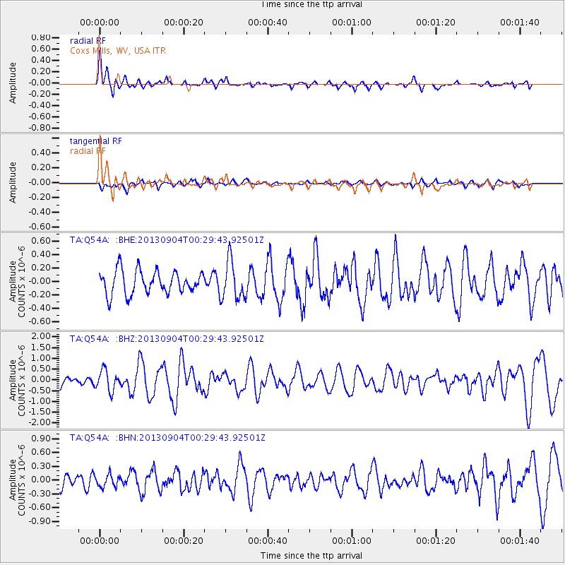
Earthquake location: Queen Charlotte Islands Region
Earthquake latitude/longitude: 51.2/-130.2
Earthquake time(UTC): 2013/09/04 (247) 00:23:11 GMT
Earthquake Depth: 9.9 km
Earthquake Magnitude: 6.0 MW, 5.9 MI, 5.9 MWR, 6.0 MWW, 6.0 MWW, 6.0 MWC
Earthquake Catalog/Contributor: NEIC PDE/NEIC COMCAT
Network: TA USArray Transportable Network (new EarthScope stations)
Station: Q54A Coxs Mills, WV, USA
Lat/Lon: 38.98 N/80.83 W
Elevation: 254 m
Distance: 36.3 deg
Az: 89.989 deg
Baz: 306.144 deg
Ray Param: 0.07676881
Estimated Moho Depth: 15.25 km
Estimated Crust Vp/Vs: 1.63
Assumed Crust Vp: 6.207 km/s
Estimated Crust Vs: 3.814 km/s
Estimated Crust Poisson's Ratio: 0.20
Radial Match: 80.2789 %
Radial Bump: 381
Transverse Match: 57.213943 %
Transverse Bump: 345
SOD ConfigId: 626651
Insert Time: 2014-04-18 09:42:15.181 +0000
GWidth: 2.5
Max Bumps: 400
Tol: 0.001

Signal To Noise

ChannelStoNSTALTA
TA:Q54A: :BHZ:20130904T00:29:43.92501Z2.35334924.829741E-72.0522839E-7
TA:Q54A: :BHN:20130904T00:29:43.92501Z0.86171381.3293345E-71.5426635E-7
TA:Q54A: :BHE:20130904T00:29:43.92501Z1.66655742.8820673E-71.7293537E-7
Arrivals
Ps1.7 SECOND
PpPs6.0 SECOND
PsPs/PpSs7.6 SECOND