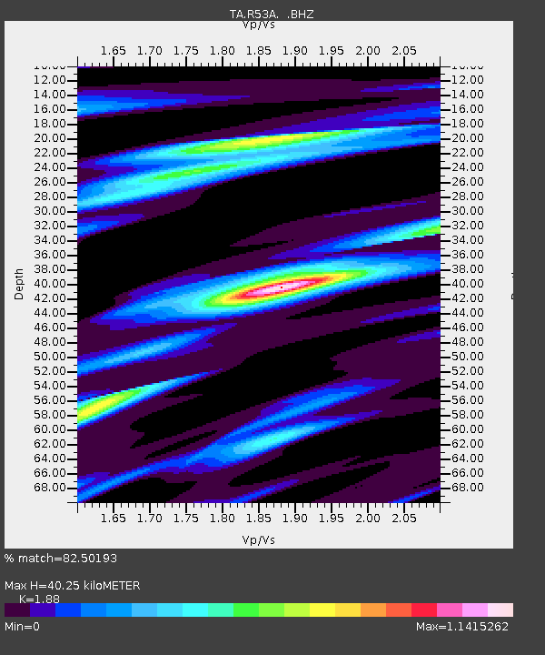
R53A Hurricane, WV, USA - Earthquake Result Viewer

Earthquake location: Queen Charlotte Islands Region
Earthquake latitude/longitude: 51.2/-130.2
Earthquake time(UTC): 2013/09/04 (247) 00:23:11 GMT
Earthquake Depth: 9.9 km
Earthquake Magnitude: 6.0 MW, 5.9 MI, 5.9 MWR, 6.0 MWW, 6.0 MWW, 6.0 MWC
Earthquake Catalog/Contributor: NEIC PDE/NEIC COMCAT
Network: TA USArray Transportable Network (new EarthScope stations)
Station: R53A Hurricane, WV, USA
Lat/Lon: 38.33 N/81.95 W
Elevation: 294 m
Distance: 36.0 deg
Az: 91.761 deg
Baz: 306.88 deg
Ray Param: 0.07694061
Estimated Moho Depth: 40.25 km
Estimated Crust Vp/Vs: 1.88
Assumed Crust Vp: 6.207 km/s
Estimated Crust Vs: 3.302 km/s
Estimated Crust Poisson's Ratio: 0.30
Radial Match: 82.50193 %
Radial Bump: 348
Transverse Match: 51.446938 %
Transverse Bump: 400
SOD ConfigId: 626651
Insert Time: 2014-04-18 09:42:30.554 +0000
GWidth: 2.5
Max Bumps: 400
Tol: 0.001

Signal To Noise

ChannelStoNSTALTA
TA:R53A: :BHZ:20130904T00:29:41.249991Z1.99158822.9947938E-71.5037213E-7
TA:R53A: :BHN:20130904T00:29:41.249991Z1.26743461.8845697E-71.4869165E-7
TA:R53A: :BHE:20130904T00:29:41.249991Z0.569020331.1244531E-71.9761212E-7
Arrivals
Ps6.1 SECOND
PpPs17 SECOND
PsPs/PpSs24 SECOND