You are here: Home > Network List > TA - USArray Transportable Network (new EarthScope stations) Stations List
> Station S56A Natural Bridge, VA, USA > Earthquake Result Viewer
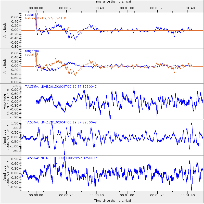
S56A Natural Bridge, VA, USA - Earthquake Result Viewer
*The percent match for this event was below the threshold and hence no stack was calculated.
| Earthquake location: |
Queen Charlotte Islands Region |
| Earthquake latitude/longitude: |
51.2/-130.2 |
| Earthquake time(UTC): |
2013/09/04 (247) 00:23:11 GMT |
| Earthquake Depth: |
9.9 km |
| Earthquake Magnitude: |
6.0 MW, 5.9 MI, 5.9 MWR, 6.0 MWW, 6.0 MWW, 6.0 MWC |
| Earthquake Catalog/Contributor: |
NEIC PDE/NEIC COMCAT |
|
| Network: |
TA USArray Transportable Network (new EarthScope stations) |
| Station: |
S56A Natural Bridge, VA, USA |
| Lat/Lon: |
37.68 N/79.57 W |
| Elevation: |
449 m |
|
| Distance: |
37.9 deg |
| Az: |
90.729 deg |
| Baz: |
307.518 deg |
| Ray Param: |
$rayparam |
*The percent match for this event was below the threshold and hence was not used in the summary stack. |
|
| Radial Match: |
66.23165 % |
| Radial Bump: |
400 |
| Transverse Match: |
32.956425 % |
| Transverse Bump: |
400 |
| SOD ConfigId: |
626651 |
| Insert Time: |
2014-04-18 09:42:55.758 +0000 |
| GWidth: |
2.5 |
| Max Bumps: |
400 |
| Tol: |
0.001 |
|
Signal To Noise
| Channel | StoN | STA | LTA |
| TA:S56A: :BHZ:20130904T00:29:57.325004Z | 3.6374168 | 4.9763776E-7 | 1.3681075E-7 |
| TA:S56A: :BHN:20130904T00:29:57.325004Z | 1.2478616 | 3.0280597E-7 | 2.426599E-7 |
| TA:S56A: :BHE:20130904T00:29:57.325004Z | 1.6313906 | 5.0614676E-7 | 3.1025482E-7 |
| Arrivals |
| Ps | |
| PpPs | |
| PsPs/PpSs | |


