You are here: Home > Network List > TA - USArray Transportable Network (new EarthScope stations) Stations List
> Station T47A Sharon Grove, KY, USA > Earthquake Result Viewer
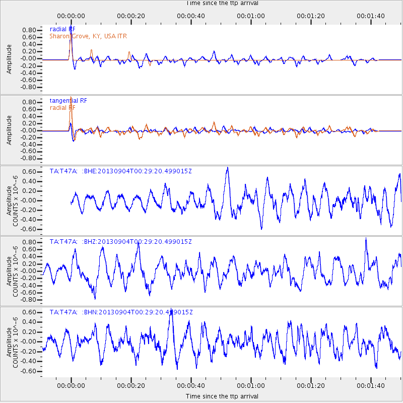
T47A Sharon Grove, KY, USA - Earthquake Result Viewer
*The percent match for this event was below the threshold and hence no stack was calculated.
| Earthquake location: |
Queen Charlotte Islands Region |
| Earthquake latitude/longitude: |
51.2/-130.2 |
| Earthquake time(UTC): |
2013/09/04 (247) 00:23:11 GMT |
| Earthquake Depth: |
9.9 km |
| Earthquake Magnitude: |
6.0 MW, 5.9 MI, 5.9 MWR, 6.0 MWW, 6.0 MWW, 6.0 MWC |
| Earthquake Catalog/Contributor: |
NEIC PDE/NEIC COMCAT |
|
| Network: |
TA USArray Transportable Network (new EarthScope stations) |
| Station: |
T47A Sharon Grove, KY, USA |
| Lat/Lon: |
36.99 N/87.11 W |
| Elevation: |
217 m |
|
| Distance: |
33.6 deg |
| Az: |
98.022 deg |
| Baz: |
308.89 deg |
| Ray Param: |
$rayparam |
*The percent match for this event was below the threshold and hence was not used in the summary stack. |
|
| Radial Match: |
78.06598 % |
| Radial Bump: |
345 |
| Transverse Match: |
55.979492 % |
| Transverse Bump: |
400 |
| SOD ConfigId: |
626651 |
| Insert Time: |
2014-04-18 09:43:05.491 +0000 |
| GWidth: |
2.5 |
| Max Bumps: |
400 |
| Tol: |
0.001 |
|
Signal To Noise
| Channel | StoN | STA | LTA |
| TA:T47A: :BHZ:20130904T00:29:20.499015Z | 2.3135686 | 2.7991499E-7 | 1.209884E-7 |
| TA:T47A: :BHN:20130904T00:29:20.499015Z | 1.9375339 | 1.5886424E-7 | 8.1993015E-8 |
| TA:T47A: :BHE:20130904T00:29:20.499015Z | 1.5857403 | 1.8749601E-7 | 1.1823879E-7 |
| Arrivals |
| Ps | |
| PpPs | |
| PsPs/PpSs | |


