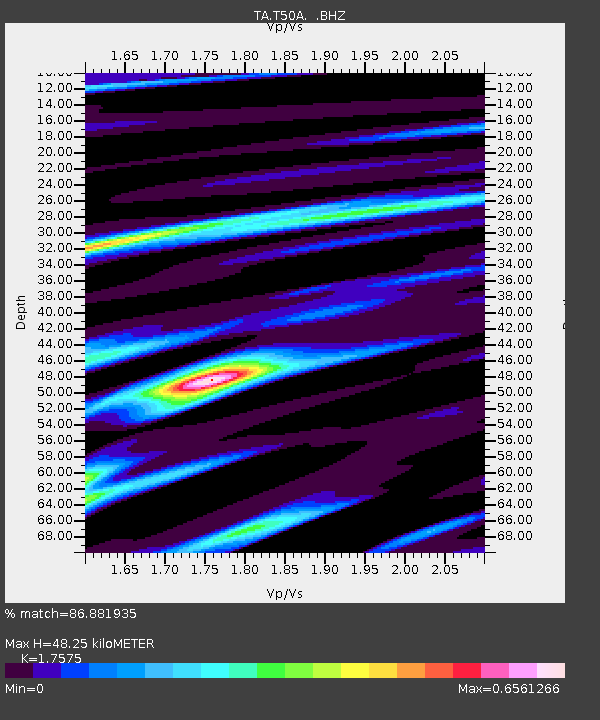
T50A Nancy, KY, USA - Earthquake Result Viewer
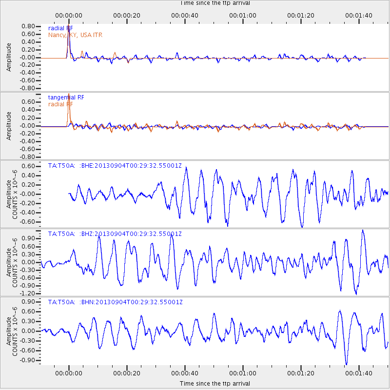
Earthquake location: Queen Charlotte Islands Region
Earthquake latitude/longitude: 51.2/-130.2
Earthquake time(UTC): 2013/09/04 (247) 00:23:11 GMT
Earthquake Depth: 9.9 km
Earthquake Magnitude: 6.0 MW, 5.9 MI, 5.9 MWR, 6.0 MWW, 6.0 MWW, 6.0 MWC
Earthquake Catalog/Contributor: NEIC PDE/NEIC COMCAT
Network: TA USArray Transportable Network (new EarthScope stations)
Station: T50A Nancy, KY, USA
Lat/Lon: 37.02 N/84.84 W
Elevation: 302 m
Distance: 34.9 deg
Az: 95.96 deg
Baz: 308.544 deg
Ray Param: 0.077478066
Estimated Moho Depth: 48.25 km
Estimated Crust Vp/Vs: 1.76
Assumed Crust Vp: 6.476 km/s
Estimated Crust Vs: 3.685 km/s
Estimated Crust Poisson's Ratio: 0.26
Radial Match: 86.881935 %
Radial Bump: 293
Transverse Match: 64.49233 %
Transverse Bump: 400
SOD ConfigId: 626651
Insert Time: 2014-04-18 09:43:09.042 +0000
GWidth: 2.5
Max Bumps: 400
Tol: 0.001

Signal To Noise

ChannelStoNSTALTA
TA:T50A: :BHZ:20130904T00:29:32.55001Z2.1851332.2741287E-71.04072775E-7
TA:T50A: :BHN:20130904T00:29:32.55001Z3.70690041.8421275E-74.969455E-8
TA:T50A: :BHE:20130904T00:29:32.55001Z2.24260431.9043785E-78.491817E-8
Arrivals
Ps6.1 SECOND
PpPs19 SECOND
PsPs/PpSs25 SECOND