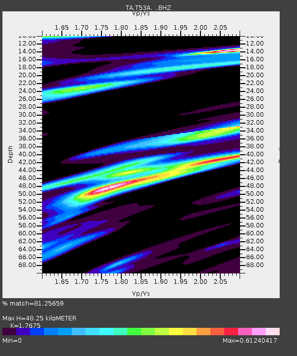
T53A Wise, VA, USA - Earthquake Result Viewer
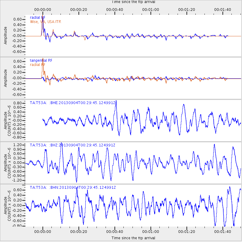
Earthquake location: Queen Charlotte Islands Region
Earthquake latitude/longitude: 51.2/-130.2
Earthquake time(UTC): 2013/09/04 (247) 00:23:11 GMT
Earthquake Depth: 9.9 km
Earthquake Magnitude: 6.0 MW, 5.9 MI, 5.9 MWR, 6.0 MWW, 6.0 MWW, 6.0 MWC
Earthquake Catalog/Contributor: NEIC PDE/NEIC COMCAT
Network: TA USArray Transportable Network (new EarthScope stations)
Station: T53A Wise, VA, USA
Lat/Lon: 36.98 N/82.54 W
Elevation: 818 m
Distance: 36.4 deg
Az: 94.045 deg
Baz: 308.369 deg
Ray Param: 0.076692805
Estimated Moho Depth: 48.25 km
Estimated Crust Vp/Vs: 1.77
Assumed Crust Vp: 6.476 km/s
Estimated Crust Vs: 3.664 km/s
Estimated Crust Poisson's Ratio: 0.26
Radial Match: 81.25659 %
Radial Bump: 358
Transverse Match: 57.90887 %
Transverse Bump: 400
SOD ConfigId: 626651
Insert Time: 2014-04-18 09:43:14.127 +0000
GWidth: 2.5
Max Bumps: 400
Tol: 0.001

Signal To Noise

ChannelStoNSTALTA
TA:T53A: :BHZ:20130904T00:29:45.124991Z3.42906864.8474914E-71.4136467E-7
TA:T53A: :BHN:20130904T00:29:45.124991Z1.08216741.264132E-71.16814824E-7
TA:T53A: :BHE:20130904T00:29:45.124991Z1.6794571.8136436E-71.07989884E-7
Arrivals
Ps6.2 SECOND
PpPs19 SECOND
PsPs/PpSs25 SECOND