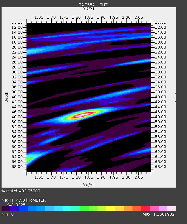
T55A Pulaski, VA, USA - Earthquake Result Viewer

Earthquake location: Queen Charlotte Islands Region
Earthquake latitude/longitude: 51.2/-130.2
Earthquake time(UTC): 2013/09/04 (247) 00:23:11 GMT
Earthquake Depth: 9.9 km
Earthquake Magnitude: 6.0 MW, 5.9 MI, 5.9 MWR, 6.0 MWW, 6.0 MWW, 6.0 MWC
Earthquake Catalog/Contributor: NEIC PDE/NEIC COMCAT
Network: TA USArray Transportable Network (new EarthScope stations)
Station: T55A Pulaski, VA, USA
Lat/Lon: 37.12 N/80.78 W
Elevation: 644 m
Distance: 37.4 deg
Az: 92.426 deg
Baz: 308.125 deg
Ray Param: 0.07613887
Estimated Moho Depth: 47.0 km
Estimated Crust Vp/Vs: 1.82
Assumed Crust Vp: 6.159 km/s
Estimated Crust Vs: 3.379 km/s
Estimated Crust Poisson's Ratio: 0.28
Radial Match: 82.95089 %
Radial Bump: 366
Transverse Match: 63.952164 %
Transverse Bump: 400
SOD ConfigId: 626651
Insert Time: 2014-04-18 09:43:18.670 +0000
GWidth: 2.5
Max Bumps: 400
Tol: 0.001

Signal To Noise

ChannelStoNSTALTA
TA:T55A: :BHZ:20130904T00:29:53.749015Z2.6266384.151099E-71.5803849E-7
TA:T55A: :BHN:20130904T00:29:53.749015Z1.60023891.9544281E-71.2213351E-7
TA:T55A: :BHE:20130904T00:29:53.749015Z1.29511231.8924322E-71.461211E-7
Arrivals
Ps6.7 SECOND
PpPs20 SECOND
PsPs/PpSs27 SECOND