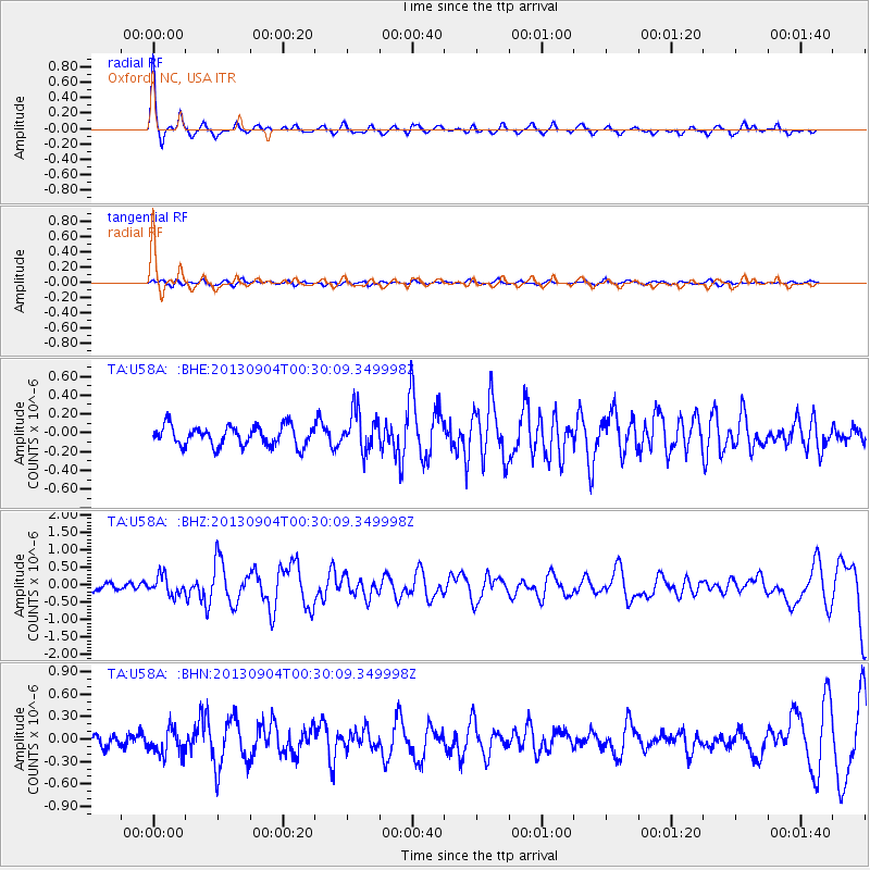
U58A Oxford, NC, USA - Earthquake Result Viewer
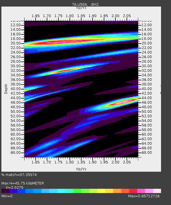
Earthquake location: Queen Charlotte Islands Region
Earthquake latitude/longitude: 51.2/-130.2
Earthquake time(UTC): 2013/09/04 (247) 00:23:11 GMT
Earthquake Depth: 9.9 km
Earthquake Magnitude: 6.0 MW, 5.9 MI, 5.9 MWR, 6.0 MWW, 6.0 MWW, 6.0 MWC
Earthquake Catalog/Contributor: NEIC PDE/NEIC COMCAT
Network: TA USArray Transportable Network (new EarthScope stations)
Station: U58A Oxford, NC, USA
Lat/Lon: 36.39 N/78.55 W
Elevation: 169 m
Distance: 39.3 deg
Az: 91.538 deg
Baz: 308.76 deg
Ray Param: 0.07507162
Estimated Moho Depth: 45.75 km
Estimated Crust Vp/Vs: 2.03
Assumed Crust Vp: 6.419 km/s
Estimated Crust Vs: 3.166 km/s
Estimated Crust Poisson's Ratio: 0.34
Radial Match: 87.35574 %
Radial Bump: 340
Transverse Match: 43.57942 %
Transverse Bump: 400
SOD ConfigId: 626651
Insert Time: 2014-04-18 09:43:47.497 +0000
GWidth: 2.5
Max Bumps: 400
Tol: 0.001

Signal To Noise

ChannelStoNSTALTA
TA:U58A: :BHZ:20130904T00:30:09.349998Z3.36924172.7200292E-78.07312E-8
TA:U58A: :BHN:20130904T00:30:09.349998Z2.2695231.6989777E-77.486057E-8
TA:U58A: :BHE:20130904T00:30:09.349998Z1.98855892.1111644E-71.06165544E-7
Arrivals
Ps7.8 SECOND
PpPs20 SECOND
PsPs/PpSs28 SECOND