V48A Smith Brothers Farm, Spring Hill, TN, USA - Earthquake Result Viewer
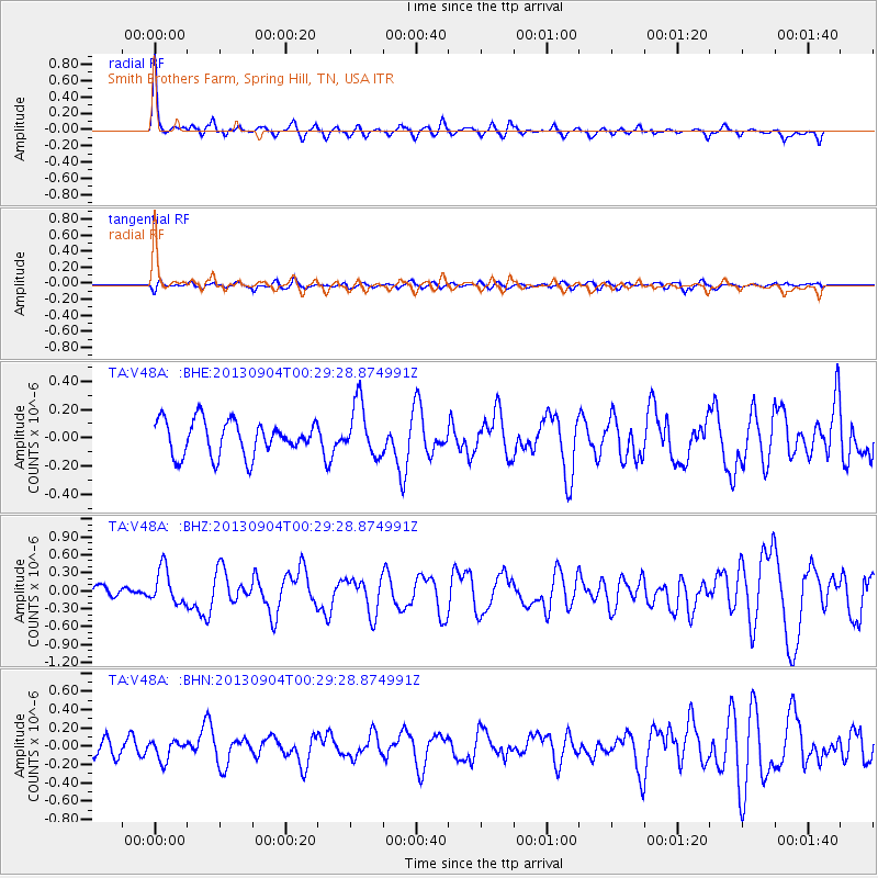
Earthquake location: Queen Charlotte Islands Region
Earthquake latitude/longitude: 51.2/-130.2
Earthquake time(UTC): 2013/09/04 (247) 00:23:11 GMT
Earthquake Depth: 9.9 km
Earthquake Magnitude: 6.0 MW, 5.9 MI, 5.9 MWR, 6.0 MWW, 6.0 MWW, 6.0 MWC
Earthquake Catalog/Contributor: NEIC PDE/NEIC COMCAT
Network: TA USArray Transportable Network (new EarthScope stations)
Station: V48A Smith Brothers Farm, Spring Hill, TN, USA
Lat/Lon: 35.74 N/86.82 W
Elevation: 278 m
Distance: 34.5 deg
Az: 99.477 deg
Baz: 310.263 deg
Ray Param: 0.07769832
Estimated Moho Depth: 47.5 km
Estimated Crust Vp/Vs: 2.10
Assumed Crust Vp: 6.476 km/s
Estimated Crust Vs: 3.087 km/s
Estimated Crust Poisson's Ratio: 0.35
Radial Match: 86.31053 %
Radial Bump: 315
Transverse Match: 55.807255 %
Transverse Bump: 400
SOD ConfigId: 626651
Insert Time: 2014-04-18 09:43:54.525 +0000
GWidth: 2.5
Max Bumps: 400
Tol: 0.001

Signal To Noise

ChannelStoNSTALTA
TA:V48A: :BHZ:20130904T00:29:28.874991Z2.15415332.9322956E-71.3612289E-7
TA:V48A: :BHN:20130904T00:29:28.874991Z1.18769221.0599901E-78.9247884E-8
TA:V48A: :BHE:20130904T00:29:28.874991Z1.5217161.8497079E-71.2155408E-7
Arrivals
Ps8.6 SECOND
PpPs21 SECOND
PsPs/PpSs30 SECOND